Lundsbrunn geodata
Lundsbrunn (Västra Götaland) is a populated place; located in Sweden in Europe/Stockholm (GMT+2) time zone. With population of 909 people, there are 877 cities with bigger population in this country. Compared to other cities in Sweden, 53.3% of cities are located further ↑North; 72.1% of cities are located further →East and 75.9% of cities have lower elevation than Lundsbrunn. Note1


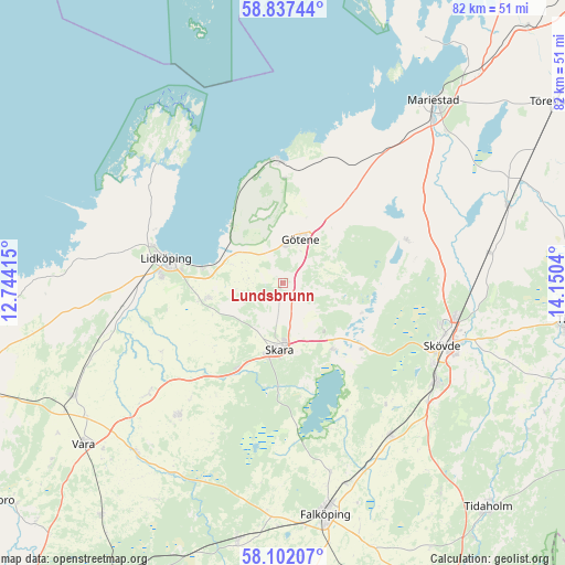
Lundsbrunn GPS coordinates[2]
58° 28' 18.048" North, 13° 26' 50.172" East
| Map corner | latitude | longitude |
|---|---|---|
| Upper-left | 58.83744°, | 12.74415° |
| Center: | 58.47168°, | 13.44727° |
| Lower-right: | 58.10207°, | 14.1504° |
| Map W x H: | 81.8×81.8 km | = 50.8×50.8mi |
| max Lat: | 67.85572° ⇑53.3% North |
| Lundsbrunn: | 58.47168° |
| min Lat: | ⇓46.7% South 55.34337° |
| min Long | Lundsbrunn | max Long |
| 11.1712° | 13.44727° | 24.13676° |
| W 27.9%⇐ | ⇒72.1% E |
Elevation
Elevation of Lundsbrunn is 124 m = 407 ft, and this is 41.4 m = 136 ft above average elevation for this country.
| Max E: |
663 m = 2175 ft | 24.1% |
| Lundsbrunn | 124 m 407 ft | |
| Avg. | 82.6 m = 271 ft | |
Min E: |
-1 m = -3 ft | 75.9% |
See also: Sweden elevation on elevation.city.
Geographical zone
Lundsbrunn is located in North temperate zone (between Tropic of Cancer and the Arctic Circle). Distance of this North polar circle is 899.7 km =559 mi to North.| Distance of | km | miles | from Lundsbrunn |
|---|---|---|---|
| North Pole | 3505.6 | 2178.3 | to North |
| Arctic Circle | 899.7 | 559 | to North |
| Tropic Cancer | 3895.5 | 2420.6 | to South |
| Equator | 6501.4 | 4039.8 | to South |


Nearby cities:
15 places around Lundsbrunn: (largest is in red/bold)
• Ardala
13.9 km =8.6 mi,  207°
207°
• Axvall
12 km =7.5 mi,  144°
144°
• Filsbäck
11.9 km =7.4 mi,  280°
280°
• Götene
6.9 km =4.3 mi,  23°
23°
• Hällekis
17.5 km =10.9 mi,  358°
358°
• Kvänum
24.5 km =15.2 mi,  218°
218°
• Källby
9.3 km =5.8 mi,  297°
297°
• Lerdala
15.4 km =9.6 mi,  87°
87°
• Lidköping
17.2 km =10.7 mi, 282°
• Lugnås
24.1 km =15 mi,  37°
37°
• Skara
9.5 km =5.9 mi,  183°
183°
• Stöpen
24.4 km =15.2 mi, 88°
• Timmersdala
18.9 km =11.7 mi,  68°
68°
• Varnhem
15.4 km =9.6 mi,  129°
129°
• Vinninga
10.8 km =6.7 mi,  257°
257°
Sources, notices
• [Note1] Compared only with cities in Sweden existing in our database
• [Src1] Map data: © OpenStreetMap contributors (CC-BY-SA)
• [Src2] Other city data from geonames.org with taken over terms of usage.
• [Src3] Geographical zone / Annual Mean Temperature by Robert A. Rohde @ Wikipedia
