Götene geodata
Götene (Västra Götaland) is a seat of a second-order administrative division; located in Sweden in Europe/Stockholm (GMT+2) time zone. With population of 5,027 people, there are 270 cities with bigger population in this country. Compared to other cities in Sweden, 52.1% of cities are located further ↑North; 71.4% of cities are located further →East and 63.6% of cities have lower elevation than Götene. Note1


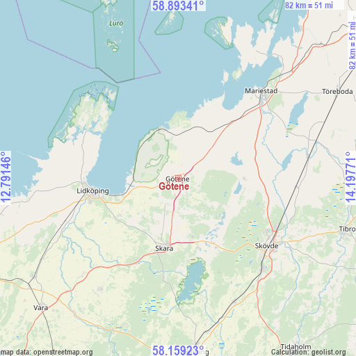
Götene GPS coordinates[2]
58° 31' 41.664" North, 13° 29' 40.488" East
| Map corner | latitude | longitude |
|---|---|---|
| Upper-left | 58.89341°, | 12.79146° |
| Center: | 58.52824°, | 13.49458° |
| Lower-right: | 58.15923°, | 14.19771° |
| Map W x H: | 81.6×81.6 km | = 50.7×50.7mi |
| max Lat: | 67.85572° ⇑52.1% North |
| Götene: | 58.52824° |
| min Lat: | ⇓47.9% South 55.34337° |
| min Long | Götene | max Long |
| 11.1712° | 13.49458° | 24.13676° |
| W 28.6%⇐ | ⇒71.4% E |
Elevation
Elevation of Götene is 79 m = 259 ft, and this is 3.6 m = 12 ft below average elevation for this country.
| Max E: |
663 m = 2175 ft | 36.4% |
| Avg. | 82.6 m = 271 ft | |
| Götene | 79 m = 259 ft | |
Min E: |
-1 m = -3 ft | 63.6% |
See also: Sweden elevation on elevation.city.
Geographical zone
Götene is located in North temperate zone (between Tropic of Cancer and the Arctic Circle). Distance of this North polar circle is 893.4 km =555.1 mi to North.| Distance of | km | miles | from Götene |
|---|---|---|---|
| North Pole | 3499.3 | 2174.4 | to North |
| Arctic Circle | 893.4 | 555.1 | to North |
| Tropic Cancer | 3901.8 | 2424.5 | to South |
| Equator | 6507.7 | 4043.7 | to South |


Nearby cities:
15 places around Götene: (largest is in red/bold)
• Ardala
20.7 km =12.9 mi,  206°
206°
• Axvall
16.6 km =10.3 mi,  165°
165°
• Filsbäck
14.9 km =9.3 mi,  254°
254°
• Hällekis
11.7 km =7.3 mi,  343°
343°
• Källby
11.1 km =6.9 mi,  259°
259°
• Lerdala
13.8 km =8.6 mi,  113°
113°
• Lidköping
19.7 km =12.2 mi, 262°
• Lugnås
17.5 km =10.9 mi,  43°
43°
• Lundsbrunn
6.9 km =4.3 mi,  203°
203°
• Skara
16.1 km =10 mi,  191°
191°
• Skövde
25.5 km =15.8 mi,  126°
126°
• Stöpen
22.3 km =13.9 mi,  104°
104°
• Timmersdala
14.8 km =9.2 mi,  87°
87°
• Varnhem
18.5 km =11.5 mi,  150°
150°
• Vinninga
15.8 km =9.8 mi,  236°
236°
Sources, notices
• [Note1] Compared only with cities in Sweden existing in our database
• [Src1] Map data: © OpenStreetMap contributors (CC-BY-SA)
• [Src2] Other city data from geonames.org with taken over terms of usage.
• [Src3] Geographical zone / Annual Mean Temperature by Robert A. Rohde @ Wikipedia
