Arbrå geodata
Arbrå (Gävleborg) is a populated place; located in Sweden in Europe/Stockholm (GMT+2) time zone. With population of 1,961 people, there are 530 cities with bigger population in this country. Compared to other cities in Sweden, 84.2% of cities are located further ↓South; 66.6% of cities are located further ←West and 72.3% of cities have lower elevation than Arbrå. Note1


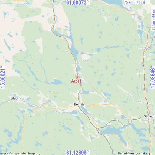
Arbrå GPS coordinates[2]
61° 28' 0.012" North, 16° 22' 59.988" East
| Map corner | latitude | longitude |
|---|---|---|
| Upper-left | 61.80073°, | 15.68021° |
| Center: | 61.46667°, | 16.38333° |
| Lower-right: | 61.12899°, | 17.08646° |
| Map W x H: | 74.7×74.7 km | = 46.4×46.4mi |
| max Lat: | 67.85572° ⇑15.8% North |
| Arbrå: | 61.46667° |
| min Lat: | ⇓84.2% South 55.34337° |
| min Long | Arbrå | max Long |
| 11.1712° | 16.38333° | 24.13676° |
| W 66.6%⇐ | ⇒33.4% E |
Elevation
Elevation of Arbrå is 107 m = 351 ft, and this is 24.4 m = 80 ft above average elevation for this country.
| Max E: |
663 m = 2175 ft | 27.7% |
| Arbrå | 107 m 351 ft | |
| Avg. | 82.6 m = 271 ft | |
Min E: |
-1 m = -3 ft | 72.3% |
See also: Sweden elevation on elevation.city.
Geographical zone
Arbrå is located in North temperate zone (between Tropic of Cancer and the Arctic Circle). Distance of this North polar circle is 566.7 km =352.1 mi to North.| Distance of | km | miles | from Arbrå |
|---|---|---|---|
| North Pole | 3172.6 | 1971.4 | to North |
| Arctic Circle | 566.7 | 352.1 | to North |
| Tropic Cancer | 4228.5 | 2627.5 | to South |
| Equator | 6834.5 | 4246.8 | to South |


Nearby cities:
15 places around Arbrå: (largest is in red/bold)
• Alfta
21.1 km =13.1 mi,  230°
230°
• Bergvik
33.5 km =20.8 mi,  135°
135°
• Bollnäs
13.2 km =8.2 mi,  177°
177°
• Delsbo
38.3 km =23.8 mi,  13°
13°
• Edsbyn
31.7 km =19.7 mi,  251°
251°
• Enånger
34.4 km =21.4 mi,  75°
75°
• Iggesund
41.5 km =25.8 mi,  61°
61°
• Järvsö
30.1 km =18.7 mi,  337°
337°
• Kilafors
27.7 km =17.2 mi,  159°
159°
• Ljusdal
43.1 km =26.8 mi, 339°
• Mohed
29.6 km =18.4 mi,  129°
129°
• Njutånger
39.1 km =24.3 mi,  65°
65°
• Näsviken
42 km =26.1 mi,  37°
37°
• Söderala
37.2 km =23.1 mi,  123°
123°
• Söderhamn
40.3 km =25 mi, 116°
Sources, notices
• [Note1] Compared only with cities in Sweden existing in our database
• [Src1] Map data: © OpenStreetMap contributors (CC-BY-SA)
• [Src2] Other city data from geonames.org with taken over terms of usage.
• [Src3] Geographical zone / Annual Mean Temperature by Robert A. Rohde @ Wikipedia
