Alsike geodata
Alsike (Uppsala) is a populated place; located in Sweden in Europe/Stockholm (GMT+2) time zone. With population of 3,833 people, there are 338 cities with bigger population in this country. Compared to other cities in Sweden, 70.5% of cities are located further ↓South; 82.6% of cities are located further ←West and 52.4% of cities have higher elevation than Alsike. Note1


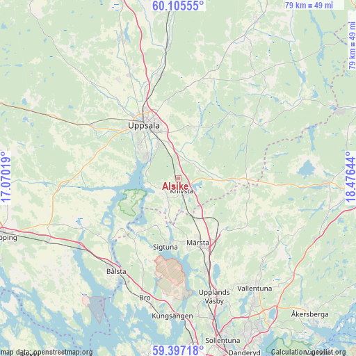
Alsike GPS coordinates[2]
59° 45' 11.664" North, 17° 46' 23.916" East
| Map corner | latitude | longitude |
|---|---|---|
| Upper-left | 60.10555°, | 17.07019° |
| Center: | 59.75324°, | 17.77331° |
| Lower-right: | 59.39718°, | 18.47644° |
| Map W x H: | 78.8×78.8 km | = 49×49mi |
| max Lat: | 67.85572° ⇑29.5% North |
| Alsike: | 59.75324° |
| min Lat: | ⇓70.5% South 55.34337° |
| min Long | Alsike | max Long |
| 11.1712° | 17.77331° | 24.13676° |
| W 82.6%⇐ | ⇒17.4% E |
Elevation
Elevation of Alsike is 46 m = 151 ft, and this is 36.6 m = 120 ft below average elevation for this country.
| Max E: |
663 m = 2175 ft | 52.4% |
| Avg. | 82.6 m = 271 ft | |
| Alsike | 46 m = 151 ft | |
Min E: |
-1 m = -3 ft | 47.6% |
See also: Sweden elevation on elevation.city.
Geographical zone
Alsike is located in North temperate zone (between Tropic of Cancer and the Arctic Circle). Distance of this North polar circle is 757.2 km =470.5 mi to North.| Distance of | km | miles | from Alsike |
|---|---|---|---|
| North Pole | 3363.1 | 2089.7 | to North |
| Arctic Circle | 757.2 | 470.5 | to North |
| Tropic Cancer | 4038 | 2509.1 | to South |
| Equator | 6643.9 | 4128.3 | to South |


Nearby cities:
15 places around Alsike: (largest is in red/bold)
• Almunge
21.2 km =13.2 mi,  46°
46°
• Gamla Uppsala
17.9 km =11.1 mi,  334°
334°
• Gunsta
11.3 km =7 mi,  17°
17°
• Gåvsta
21.9 km =13.6 mi, 15°
• Hagby
23.3 km =14.5 mi,  282°
282°
• Knivsta
3.2 km =2 mi,  165°
165°
• Länna
16.5 km =10.3 mi,  37°
37°
• Märsta
15.3 km =9.5 mi,  162°
162°
• Rosersberg
19.9 km =12.4 mi, 161°
• Sigtuna
15.4 km =9.6 mi,  190°
190°
• Steninge
16.9 km =10.5 mi, 174°
• Storvreta
23.2 km =14.4 mi,  350°
350°
• Sävja
8.4 km =5.2 mi, 330°
• Uppsala
13.9 km =8.6 mi, 327°
• Ytternäs
10.3 km =6.4 mi,  289°
289°
Sources, notices
• [Note1] Compared only with cities in Sweden existing in our database
• [Src1] Map data: © OpenStreetMap contributors (CC-BY-SA)
• [Src2] Other city data from geonames.org with taken over terms of usage.
• [Src3] Geographical zone / Annual Mean Temperature by Robert A. Rohde @ Wikipedia
