Vi geodata
Vi (Västernorrland) is a populated place; located in Sweden in Europe/Stockholm (GMT+2) time zone. With population of 5,841 people, there are 243 cities with bigger population in this country. Compared to other cities in Sweden, 87% of cities are located further ↓South; 78.8% of cities are located further ←West and 57.9% of cities have lower elevation than Vi. Note1
Administrative division(s):
- Level 1: Västernorrland
- Level 2: Sundsvalls Kommun
- Level 3: Alnö
- Level 4: Alnö socken


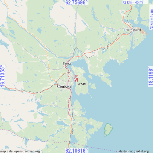
Vi GPS coordinates[2]
62° 25' 59.988" North, 17° 25' 0.012" East
| Map corner | latitude | longitude |
|---|---|---|
| Upper-left | 62.75696°, | 16.71355° |
| Center: | 62.43333°, | 17.41667° |
| Lower-right: | 62.10616°, | 18.1198° |
| Map W x H: | 72.4×72.4 km | = 45×45mi |
| max Lat: | 67.85572° ⇑13% North |
| Vi: | 62.43333° |
| min Lat: | ⇓87% South 55.34337° |
| min Long | Vi | max Long |
| 11.1712° | 17.41667° | 24.13676° |
| W 78.8%⇐ | ⇒21.2% E |
Elevation
Elevation of Vi is 65 m = 213 ft, and this is 17.6 m = 58 ft below average elevation for this country.
| Max E: |
663 m = 2175 ft | 42.1% |
| Avg. | 82.6 m = 271 ft | |
| Vi | 65 m = 213 ft | |
Min E: |
-1 m = -3 ft | 57.9% |
See also: Sweden elevation on elevation.city.
Geographical zone
Vi is located in North temperate zone (between Tropic of Cancer and the Arctic Circle). Distance of this North polar circle is 459.2 km =285.3 mi to North.| Distance of | km | miles | from Vi |
|---|---|---|---|
| North Pole | 3065.1 | 1904.6 | to North |
| Arctic Circle | 459.2 | 285.3 | to North |
| Tropic Cancer | 4336 | 2694.3 | to South |
| Equator | 6941.9 | 4313.5 | to South |


Nearby cities:
15 places around Vi: (largest is in red/bold)
• Ankarsvik
7 km =4.3 mi,  182°
182°
• Bergeforsen
11 km =6.8 mi,  350°
350°
• Dingersjö
17.7 km =11 mi,  186°
186°
• Essvik
13.1 km =8.1 mi, 185°
• Johannedal
2.3 km =1.4 mi,  272°
272°
• Klingsta
15.7 km =9.8 mi,  220°
220°
• Kvissleby
15.7 km =9.8 mi, 187°
• Njurundabommen
19 km =11.8 mi, 185°
• Nolby
16.4 km =10.2 mi, 188°
• Skottsund
15.9 km =9.9 mi, 185°
• Stockvik
11.1 km =6.9 mi, 193°
• Sundsbruk
4.4 km =2.7 mi,  308°
308°
• Sundsvall
7.4 km =4.6 mi,  230°
230°
• Söråker
9.4 km =5.8 mi,  30°
30°
• Timrå
7.5 km =4.7 mi,  321°
321°
Sources, notices
• [Note1] Compared only with cities in Sweden existing in our database
• [Src1] Map data: © OpenStreetMap contributors (CC-BY-SA)
• [Src2] Other city data from geonames.org with taken over terms of usage.
• [Src3] Geographical zone / Annual Mean Temperature by Robert A. Rohde @ Wikipedia
