Sundsbruk geodata
Sundsbruk (Västernorrland) is a populated place; located in Sweden in Europe/Stockholm (GMT+2) time zone. With population of 2,098 people, there are 507 cities with bigger population in this country. Compared to other cities in Sweden, 87.2% of cities are located further ↓South; 77.9% of cities are located further ←West and 57.4% of cities have higher elevation than Sundsbruk. Note1


Sundsbruk GPS coordinates[2]
62° 27' 29.016" North, 17° 20' 56.004" East
| Map corner | latitude | longitude |
|---|---|---|
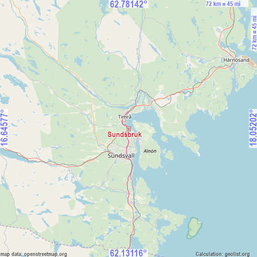
| Upper-left | 62.78142°, | 16.64577° |
| Center: | 62.45806°, | 17.34889° |
| Lower-right: | 62.13116°, | 18.05202° |
| Map W x H: | 72.3×72.3 km | = 44.9×44.9mi |
| max Lat: | 67.85572° ⇑12.8% North |
| Sundsbruk: | 62.45806° |
| min Lat: | ⇓87.2% South 55.34337° |
| min Long | Sundsbruk | max Long |
| 11.1712° | 17.34889° | 24.13676° |
| W 77.9%⇐ | ⇒22.1% E |
Elevation
Elevation of Sundsbruk is 39 m = 128 ft, and this is 43.6 m = 143 ft below average elevation for this country.
| Max E: |
663 m = 2175 ft | 57.4% |
| Avg. | 82.6 m = 271 ft | |
| Sundsbruk | 39 m = 128 ft | |
Min E: |
-1 m = -3 ft | 42.6% |
See also: Sweden elevation on elevation.city.
Geographical zone
Sundsbruk is located in North temperate zone (between Tropic of Cancer and the Arctic Circle). Distance of this North polar circle is 456.5 km =283.7 mi to North.| Distance of | km | miles | from Sundsbruk |
|---|---|---|---|
| North Pole | 3062.4 | 1902.9 | to North |
| Arctic Circle | 456.5 | 283.7 | to North |
| Tropic Cancer | 4338.8 | 2696 | to South |
| Equator | 6944.7 | 4315.2 | to South |


Nearby cities:
15 places around Sundsbruk: (largest is in red/bold)
• Ankarsvik
10.3 km =6.4 mi,  161°
161°
• Bergeforsen
8.3 km =5.2 mi,  11°
11°
• Essvik
15.9 km =9.9 mi,  171°
171°
• Högsjö
15 km =9.3 mi,  298°
298°
• Indal
18.5 km =11.5 mi,  315°
315°
• Johannedal
2.9 km =1.8 mi, 155°
• Klingsta
16.1 km =10 mi,  204°
204°
• Kvissleby
18.3 km =11.4 mi,  175°
175°
• Nolby
19 km =11.8 mi, 176°
• Skottsund
18.7 km =11.6 mi, 173°
• Stockvik
13.5 km =8.4 mi, 176°
• Sundsvall
7.7 km =4.8 mi, 196°
• Söråker
9.8 km =6.1 mi,  57°
57°
• Timrå
3.4 km =2.1 mi,  339°
339°
• Vi
4.4 km =2.7 mi,  128°
128°
Sources, notices
• [Note1] Compared only with cities in Sweden existing in our database
• [Src1] Map data: © OpenStreetMap contributors (CC-BY-SA)
• [Src2] Other city data from geonames.org with taken over terms of usage.
• [Src3] Geographical zone / Annual Mean Temperature by Robert A. Rohde @ Wikipedia
