Timrå geodata
Timrå (Västernorrland) is a seat of a second-order administrative division; located in Sweden in Europe/Stockholm (GMT+2) time zone. With population of 10,495 people, there are 145 cities with bigger population in this country. Compared to other cities in Sweden, 87.3% of cities are located further ↓South; 77.6% of cities are located further ←West and 99.8% of cities have higher elevation than Timrå. Note1
Administrative division(s):
- Level 1: Västernorrland
- Level 2: Timrå Kommun
- Level 3: Timrå
- Level 4: Timrå socken


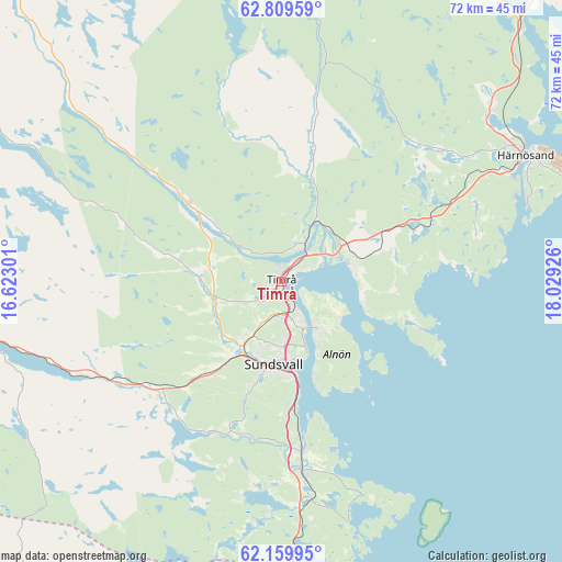
Timrå GPS coordinates[2]
62° 29' 11.544" North, 17° 19' 34.068" East
| Map corner | latitude | longitude |
|---|---|---|
| Upper-left | 62.80959°, | 16.62301° |
| Center: | 62.48654°, | 17.32613° |
| Lower-right: | 62.15995°, | 18.02926° |
| Map W x H: | 72.2×72.2 km | = 44.9×44.9mi |
| max Lat: | 67.85572° ⇑12.7% North |
| Timrå: | 62.48654° |
| min Lat: | ⇓87.3% South 55.34337° |
| min Long | Timrå | max Long |
| 11.1712° | 17.32613° | 24.13676° |
| W 77.6%⇐ | ⇒22.4% E |
Elevation
Elevation of Timrå is 1 m = 3 ft, and this is 81.6 m = 268 ft below average elevation for this country.
| Max E: |
663 m = 2175 ft | 99.8% |
| Avg. | 82.6 m = 271 ft | |
| Timrå | 1 m = 3 ft | |
Min E: |
-1 m = -3 ft | 0.2% |
See also: Sweden elevation on elevation.city.
Geographical zone
Timrå is located in North temperate zone (between Tropic of Cancer and the Arctic Circle). Distance of this North polar circle is 453.3 km =281.7 mi to North.| Distance of | km | miles | from Timrå |
|---|---|---|---|
| North Pole | 3059.2 | 1900.9 | to North |
| Arctic Circle | 453.3 | 281.7 | to North |
| Tropic Cancer | 4341.9 | 2697.9 | to South |
| Equator | 6947.9 | 4317.2 | to South |


Nearby cities:
15 places around Timrå: (largest is in red/bold)
• Ankarsvik
13.7 km =8.5 mi,  161°
161°
• Bergeforsen
5.7 km =3.5 mi,  29°
29°
• Essvik
19.2 km =11.9 mi,  169°
169°
• Högsjö
12.7 km =7.9 mi,  288°
288°
• Indal
15.4 km =9.6 mi,  310°
310°
• Johannedal
6.3 km =3.9 mi, 157°
• Klingsta
18.6 km =11.6 mi,  197°
197°
• Kvissleby
21.6 km =13.4 mi, 173°
• Matfors
21.6 km =13.4 mi,  224°
224°
• Stockvik
16.8 km =10.4 mi, 173°
• Sundsbruk
3.4 km =2.1 mi, 159°
• Sundsvall
10.6 km =6.6 mi,  185°
185°
• Söråker
9.7 km =6 mi,  77°
77°
• Vattjom
21.4 km =13.3 mi,  231°
231°
• Vi
7.5 km =4.7 mi,  141°
141°
Sources, notices
• [Note1] Compared only with cities in Sweden existing in our database
• [Src1] Map data: © OpenStreetMap contributors (CC-BY-SA)
• [Src2] Other city data from geonames.org with taken over terms of usage.
• [Src3] Geographical zone / Annual Mean Temperature by Robert A. Rohde @ Wikipedia
