Norsjö geodata
Norsjö (Västerbotten) is a seat of a second-order administrative division; located in Sweden in Europe/Stockholm (GMT+2) time zone. With population of 2,057 people, there are 511 cities with bigger population in this country. Compared to other cities in Sweden, 95.4% of cities are located further ↓South; 93.5% of cities are located further ←West and 96.1% of cities have lower elevation than Norsjö. Note1


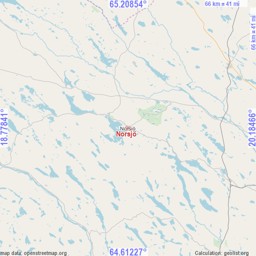
Norsjö GPS coordinates[2]
64° 54' 43.416" North, 19° 28' 53.508" East
| Map corner | latitude | longitude |
|---|---|---|
| Upper-left | 65.20854°, | 18.77841° |
| Center: | 64.91206°, | 19.48153° |
| Lower-right: | 64.61227°, | 20.18466° |
| Map W x H: | 66.3×66.3 km | = 41.2×41.2mi |
| max Lat: | 67.85572° ⇑4.6% North |
| Norsjö: | 64.91206° |
| min Lat: | ⇓95.4% South 55.34337° |
| min Long | Norsjö | max Long |
| 11.1712° | 19.48153° | 24.13676° |
| W 93.5%⇐ | ⇒6.5% E |
Elevation
Elevation of Norsjö is 300 m = 984 ft, and this is 217.4 m = 713 ft above average elevation for this country.
| Max E: |
663 m = 2175 ft | 3.9% |
| Norsjö | 300 m 984 ft | |
| Avg. | 82.6 m = 271 ft | |
Min E: |
-1 m = -3 ft | 96.1% |
See also: Sweden elevation on elevation.city.
Geographical zone
Norsjö is located in North temperate zone (between Tropic of Cancer and the Arctic Circle). Distance of this North polar circle is 183.6 km =114.1 mi to North.| Distance of | km | miles | from Norsjö |
|---|---|---|---|
| North Pole | 2789.5 | 1733.3 | to North |
| Arctic Circle | 183.6 | 114.1 | to North |
| Tropic Cancer | 4611.6 | 2865.5 | to South |
| Equator | 7217.5 | 4484.7 | to South |


Nearby cities:
15 places around Norsjö: (largest is in red/bold)
• Boliden
42.8 km =26.6 mi,  96°
96°
• Burträsk
70.8 km =44 mi,  128°
128°
• Ersmark
67.1 km =41.7 mi, 96°
• Forsbacka
50.8 km =31.6 mi,  108°
108°
• Jörn
30.9 km =19.2 mi,  58°
58°
• Lycksele
52 km =32.3 mi,  227°
227°
• Långsele
37.8 km =23.5 mi, 106°
• Malå
46.1 km =28.6 mi,  311°
311°
• Medle
62.2 km =38.6 mi, 108°
• Nyland
61.6 km =38.3 mi, 99°
• Storvik
64.4 km =40 mi,  65°
65°
• Svartå
61.9 km =38.5 mi,  77°
77°
• Söderfors
68.4 km =42.5 mi,  261°
261°
• Tällberg
62.6 km =38.9 mi, 82°
• Viken
70.9 km =44.1 mi, 106°
Sources, notices
• [Note1] Compared only with cities in Sweden existing in our database
• [Src1] Map data: © OpenStreetMap contributors (CC-BY-SA)
• [Src2] Other city data from geonames.org with taken over terms of usage.
• [Src3] Geographical zone / Annual Mean Temperature by Robert A. Rohde @ Wikipedia
