Holmsund geodata
Holmsund (Västerbotten) is a populated place; located in Sweden in Europe/Stockholm (GMT+2) time zone. With population of 5,962 people, there are 237 cities with bigger population in this country. Compared to other cities in Sweden, 92.2% of cities are located further ↓South; 94.7% of cities are located further ←West and 85.7% of cities have higher elevation than Holmsund. Note1


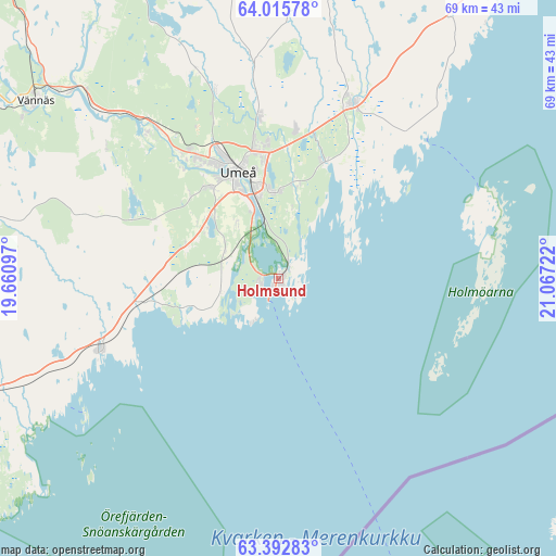
Holmsund GPS coordinates[2]
63° 42' 21.672" North, 20° 21' 50.724" East
| Map corner | latitude | longitude |
|---|---|---|
| Upper-left | 64.01578°, | 19.66097° |
| Center: | 63.70602°, | 20.36409° |
| Lower-right: | 63.39283°, | 21.06722° |
| Map W x H: | 69.3×69.3 km | = 43.1×43.1mi |
| max Lat: | 67.85572° ⇑7.8% North |
| Holmsund: | 63.70602° |
| min Lat: | ⇓92.2% South 55.34337° |
| min Long | Holmsund | max Long |
| 11.1712° | 20.36409° | 24.13676° |
| W 94.7%⇐ | ⇒5.3% E |
Elevation
Elevation of Holmsund is 12 m = 39 ft, and this is 70.6 m = 232 ft below average elevation for this country.
| Max E: |
663 m = 2175 ft | 85.7% |
| Avg. | 82.6 m = 271 ft | |
| Holmsund | 12 m = 39 ft | |
Min E: |
-1 m = -3 ft | 14.3% |
See also: Sweden elevation on elevation.city.
Geographical zone
Holmsund is located in North temperate zone (between Tropic of Cancer and the Arctic Circle). Distance of this North polar circle is 317.7 km =197.4 mi to North.| Distance of | km | miles | from Holmsund |
|---|---|---|---|
| North Pole | 2923.6 | 1816.6 | to North |
| Arctic Circle | 317.7 | 197.4 | to North |
| Tropic Cancer | 4477.5 | 2782.2 | to South |
| Equator | 7083.4 | 4401.4 | to South |


Nearby cities:
15 places around Holmsund: (largest is in red/bold)
• Bygdeå
46.1 km =28.6 mi,  31°
31°
• Ersmark
19.9 km =12.4 mi,  353°
353°
• Hörnefors
24.3 km =15.1 mi,  247°
247°
• Innertavle
11.9 km =7.4 mi,  10°
10°
• Lögdeå
51.3 km =31.9 mi, 250°
• Nordmaling
45.2 km =28.1 mi, 250°
• Obbola
2.4 km =1.5 mi, 254°
• Rundvik
49.8 km =30.9 mi, 247°
• Röbäck
14.3 km =8.9 mi,  323°
323°
• Sävar
23.8 km =14.8 mi,  22°
22°
• Tomtebo
10.9 km =6.8 mi,  1°
1°
• Täfteå
15.9 km =9.9 mi, 20°
• Umeå
14.5 km =9 mi,  339°
339°
• Vännäs
37.2 km =23.1 mi,  306°
306°
• Vännäsby
35.3 km =21.9 mi, 311°
Sources, notices
• [Note1] Compared only with cities in Sweden existing in our database
• [Src1] Map data: © OpenStreetMap contributors (CC-BY-SA)
• [Src2] Other city data from geonames.org with taken over terms of usage.
• [Src3] Geographical zone / Annual Mean Temperature by Robert A. Rohde @ Wikipedia
