Umeå geodata
Umeå (Västerbotten) is a seat of a first-order administrative division; located in Sweden in Europe/Stockholm (GMT+2) time zone. With population of 83,249 people, there are 14 cities with bigger population in this country. Compared to other cities in Sweden, 92.5% of cities are located further ↓South; 94.4% of cities are located further ←West and 70.9% of cities have higher elevation than Umeå. Note1


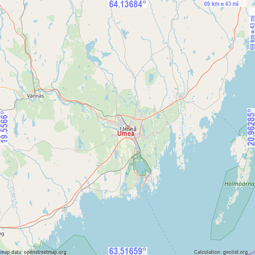
Umeå GPS coordinates[2]
63° 49' 42.312" North, 20° 15' 34.992" East
| Map corner | latitude | longitude |
|---|---|---|
| Upper-left | 64.13684°, | 19.5566° |
| Center: | 63.82842°, | 20.25972° |
| Lower-right: | 63.51659°, | 20.96285° |
| Map W x H: | 69×69 km | = 42.9×42.9mi |
| max Lat: | 67.85572° ⇑7.5% North |
| Umeå: | 63.82842° |
| min Lat: | ⇓92.5% South 55.34337° |
| min Long | Umeå | max Long |
| 11.1712° | 20.25972° | 24.13676° |
| W 94.4%⇐ | ⇒5.6% E |
Elevation
Elevation of Umeå is 24 m = 79 ft, and this is 58.6 m = 192 ft below average elevation for this country.
| Max E: |
663 m = 2175 ft | 70.9% |
| Avg. | 82.6 m = 271 ft | |
| Umeå | 24 m = 79 ft | |
Min E: |
-1 m = -3 ft | 29.1% |
See also: Umeå elevation on elevation.city.
Geographical zone
Umeå is located in North temperate zone (between Tropic of Cancer and the Arctic Circle). Distance of this North polar circle is 304.1 km =189 mi to North.| Distance of | km | miles | from Umeå |
|---|---|---|---|
| North Pole | 2910 | 1808.2 | to North |
| Arctic Circle | 304.1 | 189 | to North |
| Tropic Cancer | 4491.1 | 2790.6 | to South |
| Equator | 7097.1 | 4409.9 | to South |


Nearby cities:
15 places around Umeå: (largest is in red/bold)
• Bygdeå
38.9 km =24.2 mi,  48°
48°
• Ersmark
6.7 km =4.2 mi,  24°
24°
• Holmsund
14.5 km =9 mi,  159°
159°
• Hörnefors
28.6 km =17.8 mi,  217°
217°
• Innertavle
7.5 km =4.7 mi,  104°
104°
• Nordmaling
47.2 km =29.3 mi,  232°
232°
• Obbola
14.6 km =9.1 mi,  168°
168°
• Ramsele
43.6 km =27.1 mi,  307°
307°
• Röbäck
4.1 km =2.5 mi,  237°
237°
• Sävar
16.5 km =10.3 mi,  59°
59°
• Tomtebo
6 km =3.7 mi,  116°
116°
• Täfteå
10.8 km =6.7 mi,  83°
83°
• Vindeln
49.2 km =30.6 mi,  327°
327°
• Vännäs
26.1 km =16.2 mi,  289°
289°
• Vännäsby
23.4 km =14.5 mi, 294°
Sources, notices
• [Note1] Compared only with cities in Sweden existing in our database
• [Src1] Map data: © OpenStreetMap contributors (CC-BY-SA)
• [Src2] Other city data from geonames.org with taken over terms of usage.
• [Src3] Geographical zone / Annual Mean Temperature by Robert A. Rohde @ Wikipedia
