Tomtebo geodata
Tomtebo (Västerbotten) is a section of populated place; located in Sweden in Europe/Stockholm (GMT+2) time zone. With population of 741 people, there are 1021 cities with bigger population in this country. Compared to other cities in Sweden, 92.2% of cities are located further ↓South; 94.8% of cities are located further ←West and 55.2% of cities have higher elevation than Tomtebo. Note1


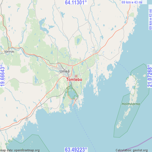
Tomtebo GPS coordinates[2]
63° 48' 15.588" North, 20° 22' 10.38" East
| Map corner | latitude | longitude |
|---|---|---|
| Upper-left | 64.11301°, | 19.66643° |
| Center: | 63.80433°, | 20.36955° |
| Lower-right: | 63.49223°, | 21.07268° |
| Map W x H: | 69×69 km | = 42.9×42.9mi |
| max Lat: | 67.85572° ⇑7.8% North |
| Tomtebo: | 63.80433° |
| min Lat: | ⇓92.2% South 55.34337° |
| min Long | Tomtebo | max Long |
| 11.1712° | 20.36955° | 24.13676° |
| W 94.8%⇐ | ⇒5.2% E |
Elevation
Elevation of Tomtebo is 42 m = 138 ft, and this is 40.6 m = 133 ft below average elevation for this country.
| Max E: |
663 m = 2175 ft | 55.2% |
| Avg. | 82.6 m = 271 ft | |
| Tomtebo | 42 m = 138 ft | |
Min E: |
-1 m = -3 ft | 44.8% |
See also: Sweden elevation on elevation.city.
Geographical zone
Tomtebo is located in North temperate zone (between Tropic of Cancer and the Arctic Circle). Distance of this North polar circle is 306.8 km =190.6 mi to North.| Distance of | km | miles | from Tomtebo |
|---|---|---|---|
| North Pole | 2912.7 | 1809.9 | to North |
| Arctic Circle | 306.8 | 190.6 | to North |
| Tropic Cancer | 4488.5 | 2789 | to South |
| Equator | 7094.4 | 4408.3 | to South |


Nearby cities:
15 places around Tomtebo: (largest is in red/bold)
• Bygdeå
37 km =23 mi,  39°
39°
• Ersmark
9.2 km =5.7 mi,  343°
343°
• Holmsund
10.9 km =6.8 mi,  181°
181°
• Hörnefors
30.4 km =18.9 mi,  228°
228°
• Innertavle
2 km =1.2 mi,  67°
67°
• Nordmaling
50.1 km =31.1 mi,  238°
238°
• Obbola
11.9 km =7.4 mi,  192°
192°
• Ramsele
49.5 km =30.8 mi,  306°
306°
• Robertsfors
49.1 km =30.5 mi,  28°
28°
• Röbäck
8.9 km =5.5 mi,  273°
273°
• Sävar
14.2 km =8.8 mi, 38°
• Täfteå
6.6 km =4.1 mi,  53°
53°
• Umeå
6 km =3.7 mi,  296°
296°
• Vännäs
32.1 km =19.9 mi,  290°
290°
• Vännäsby
29.4 km =18.3 mi, 294°
Sources, notices
• [Note1] Compared only with cities in Sweden existing in our database
• [Src1] Map data: © OpenStreetMap contributors (CC-BY-SA)
• [Src2] Other city data from geonames.org with taken over terms of usage.
• [Src3] Geographical zone / Annual Mean Temperature by Robert A. Rohde @ Wikipedia
