Vännäs geodata
Vännäs (Västerbotten) is a seat of a second-order administrative division; located in Sweden in Europe/Stockholm (GMT+2) time zone. With population of 4,373 people, there are 308 cities with bigger population in this country. Compared to other cities in Sweden, 92.9% of cities are located further ↓South; 93.8% of cities are located further ←West and 64.6% of cities have lower elevation than Vännäs. Note1


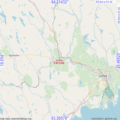
Vännäs GPS coordinates[2]
63° 54' 24.336" North, 19° 45' 25.632" East
| Map corner | latitude | longitude |
|---|---|---|
| Upper-left | 64.21432°, | 19.054° |
| Center: | 63.90676°, | 19.75712° |
| Lower-right: | 63.59579°, | 20.46025° |
| Map W x H: | 68.8×68.8 km | = 42.8×42.8mi |
| max Lat: | 67.85572° ⇑7.1% North |
| Vännäs: | 63.90676° |
| min Lat: | ⇓92.9% South 55.34337° |
| min Long | Vännäs | max Long |
| 11.1712° | 19.75712° | 24.13676° |
| W 93.8%⇐ | ⇒6.2% E |
Elevation
Elevation of Vännäs is 81 m = 266 ft, and this is 1.6 m = 5 ft below average elevation for this country.
| Max E: |
663 m = 2175 ft | 35.4% |
| Avg. | 82.6 m = 271 ft | |
| Vännäs | 81 m = 266 ft | |
Min E: |
-1 m = -3 ft | 64.6% |
See also: Sweden elevation on elevation.city.
Geographical zone
Vännäs is located in North temperate zone (between Tropic of Cancer and the Arctic Circle). Distance of this North polar circle is 295.4 km =183.6 mi to North.| Distance of | km | miles | from Vännäs |
|---|---|---|---|
| North Pole | 2901.3 | 1802.8 | to North |
| Arctic Circle | 295.4 | 183.6 | to North |
| Tropic Cancer | 4499.8 | 2796 | to South |
| Equator | 7105.8 | 4415.3 | to South |


Nearby cities:
15 places around Vännäs: (largest is in red/bold)
• Bjurholm
26.7 km =16.6 mi,  275°
275°
• Ersmark
27.5 km =17.1 mi,  95°
95°
• Holmsund
37.2 km =23.1 mi,  126°
126°
• Hörnefors
32.4 km =20.1 mi,  166°
166°
• Innertavle
33.6 km =20.9 mi,  108°
108°
• Obbola
35.8 km =22.2 mi, 129°
• Ramsele
20.4 km =12.7 mi,  330°
330°
• Röbäck
23.8 km =14.8 mi,  117°
117°
• Sunnansjö
29.2 km =18.1 mi,  317°
317°
• Sävar
38.8 km =24.1 mi,  90°
90°
• Tomtebo
32.1 km =19.9 mi, 110°
• Täfteå
36.1 km =22.4 mi, 101°
• Umeå
26.1 km =16.2 mi, 109°
• Vindeln
32.9 km =20.4 mi,  356°
356°
• Vännäsby
3.4 km =2.1 mi,  73°
73°
Sources, notices
• [Note1] Compared only with cities in Sweden existing in our database
• [Src1] Map data: © OpenStreetMap contributors (CC-BY-SA)
• [Src2] Other city data from geonames.org with taken over terms of usage.
• [Src3] Geographical zone / Annual Mean Temperature by Robert A. Rohde @ Wikipedia
