Sävar geodata
Sävar (Västerbotten) is a populated place; located in Sweden in Europe/Stockholm (GMT+2) time zone. With population of 2,968 people, there are 408 cities with bigger population in this country. Compared to other cities in Sweden, 92.8% of cities are located further ↓South; 95.3% of cities are located further ←West and 56% of cities have higher elevation than Sävar. Note1


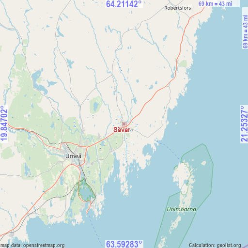
Sävar GPS coordinates[2]
63° 54' 13.788" North, 20° 33' 0.504" East
| Map corner | latitude | longitude |
|---|---|---|
| Upper-left | 64.21142°, | 19.84702° |
| Center: | 63.90383°, | 20.55014° |
| Lower-right: | 63.59283°, | 21.25327° |
| Map W x H: | 68.8×68.8 km | = 42.8×42.8mi |
| max Lat: | 67.85572° ⇑7.2% North |
| Sävar: | 63.90383° |
| min Lat: | ⇓92.8% South 55.34337° |
| min Long | Sävar | max Long |
| 11.1712° | 20.55014° | 24.13676° |
| W 95.3%⇐ | ⇒4.7% E |
Elevation
Elevation of Sävar is 41 m = 135 ft, and this is 41.6 m = 136 ft below average elevation for this country.
| Max E: |
663 m = 2175 ft | 56% |
| Avg. | 82.6 m = 271 ft | |
| Sävar | 41 m = 135 ft | |
Min E: |
-1 m = -3 ft | 44% |
See also: Sweden elevation on elevation.city.
Geographical zone
Sävar is located in North temperate zone (between Tropic of Cancer and the Arctic Circle). Distance of this North polar circle is 295.7 km =183.7 mi to North.| Distance of | km | miles | from Sävar |
|---|---|---|---|
| North Pole | 2901.6 | 1803 | to North |
| Arctic Circle | 295.7 | 183.7 | to North |
| Tropic Cancer | 4499.5 | 2795.9 | to South |
| Equator | 7105.4 | 4415.1 | to South |


Nearby cities:
15 places around Sävar: (largest is in red/bold)
• Bygdeå
22.9 km =14.2 mi,  40°
40°
• Ersmark
11.6 km =7.2 mi,  258°
258°
• Holmsund
23.8 km =14.8 mi,  202°
202°
• Hörnefors
44.4 km =27.6 mi,  225°
225°
• Innertavle
12.4 km =7.7 mi,  214°
214°
• Obbola
25.4 km =15.8 mi, 206°
• Ramsele
52 km =32.3 mi,  290°
290°
• Robertsfors
35.3 km =21.9 mi,  24°
24°
• Röbäck
20.6 km =12.8 mi,  239°
239°
• Tomtebo
14.2 km =8.8 mi,  218°
218°
• Täfteå
7.9 km =4.9 mi, 206°
• Umeå
16.5 km =10.3 mi, 239°
• Vännäs
38.8 km =24.1 mi,  270°
270°
• Vännäsby
35.5 km =22.1 mi, 272°
• Ånäset
47.1 km =29.3 mi,  31°
31°
Sources, notices
• [Note1] Compared only with cities in Sweden existing in our database
• [Src1] Map data: © OpenStreetMap contributors (CC-BY-SA)
• [Src2] Other city data from geonames.org with taken over terms of usage.
• [Src3] Geographical zone / Annual Mean Temperature by Robert A. Rohde @ Wikipedia
