Tržič geodata
Tržič is a seat of a first-order administrative division; located in Slovenia in Europe/Ljubljana (GMT+2) time zone. With population of 3,865 people, there are 48 cities with bigger population in this country. Compared to other cities in Slovenia, 61.8% of cities are located further ↓South; 76.3% of cities are located further →East and 88.8% of cities have lower elevation than Tržič. Note1


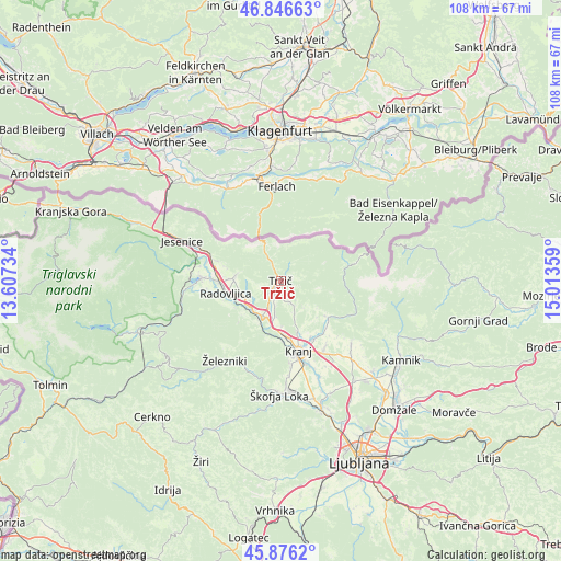
Tržič GPS coordinates[2]
46° 21' 48.852" North, 14° 18' 37.656" East
| Map corner | latitude | longitude |
|---|---|---|
| Upper-left | 46.84663°, | 13.60734° |
| Center: | 46.36357°, | 14.31046° |
| Lower-right: | 45.8762°, | 15.01359° |
| Map W x H: | 107.9×107.9 km | = 67×67mi |
| max Lat: | 46.83694° ⇑38.2% North |
| Tržič: | 46.36357° |
| min Lat: | ⇓61.8% South 45.47667° |
| min Long | Tržič | max Long |
| 13.52639° | 14.31046° | 16.4975° |
| W 23.7%⇐ | ⇒76.3% E |
Elevation
Elevation of Tržič is 519 m = 1703 ft, and this is 193.4 m = 635 ft above average elevation for this country.
| Max E: |
1551 m = 5089 ft | 11.2% |
| Tržič | 519 m 1703 ft | |
| Avg. | 325.6 m = 1068 ft | |
Min E: |
2 m = 7 ft | 88.8% |
See also: Slovenia elevation on elevation.city.
Geographical zone
Tržič is located in North temperate zone (between Tropic of Cancer and the Arctic Circle). Distance of this North polar circle is 2246 km =1395.6 mi to North.| Distance of | km | miles | from Tržič |
|---|---|---|---|
| North Pole | 4851.9 | 3014.8 | to North |
| Arctic Circle | 2246 | 1395.6 | to North |
| Tropic Cancer | 2549.2 | 1584 | to South |
| Equator | 5155.1 | 3203.2 | to South |


Nearby cities:
15 places around Tržič: (largest is in red/bold)
• Begunje na Gorenjskem
7.5 km =4.7 mi,  286°
286°
• Bistrica pri Tržiču
1.7 km =1.1 mi,  235°
235°
• Brezje
7.1 km =4.4 mi, 237°
• Golnik
3.8 km =2.4 mi,  152°
152°
• Kamna Gorica
10 km =6.2 mi, 238°
• Kovor
2.6 km =1.6 mi,  234°
234°
• Križe
2.4 km =1.5 mi,  196°
196°
• Mlaka pri Kranju
9.4 km =5.8 mi,  161°
161°
• Podbrezje
7.4 km =4.6 mi, 196°
• Podljubelj
6 km =3.7 mi,  333°
333°
• Pristava
1.8 km =1.1 mi,  205°
205°
• Ročevnica
2.2 km =1.4 mi, 240°
• Spodnje Duplje
7.1 km =4.4 mi,  186°
186°
• Strahinj
8.9 km =5.5 mi,  176°
176°
• Zgornje Duplje
6.4 km =4 mi, 193°
Sources, notices
• [Note1] Compared only with cities in Slovenia existing in our database
• [Src1] Map data: © OpenStreetMap contributors (CC-BY-SA)
• [Src2] Other city data from geonames.org with taken over terms of usage.
• [Src3] Geographical zone / Annual Mean Temperature by Robert A. Rohde @ Wikipedia
