Podljubelj geodata
Podljubelj (Tržič) is a populated place; located in Slovenia in Europe/Ljubljana (GMT+2) time zone. With population of 807 people, there are 292 cities with bigger population in this country. Compared to other cities in Slovenia, 69.5% of cities are located further ↓South; 79.3% of cities are located further →East and 97.5% of cities have lower elevation than Podljubelj. Note1


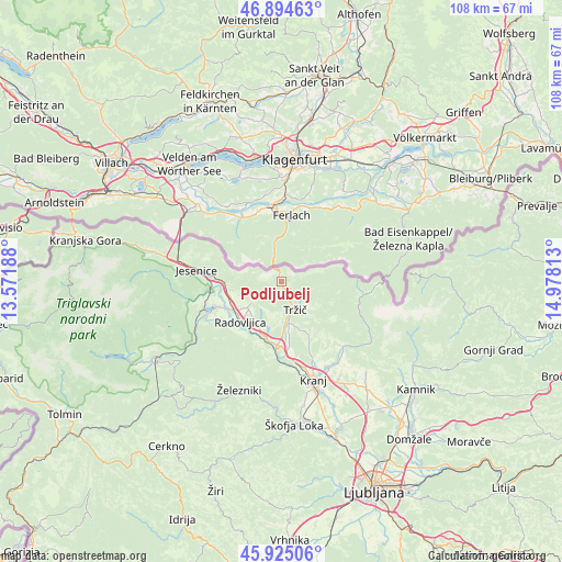
Podljubelj GPS coordinates[2]
46° 24' 43.2" North, 14° 16' 30" East
| Map corner | latitude | longitude |
|---|---|---|
| Upper-left | 46.89463°, | 13.57188° |
| Center: | 46.412°, | 14.275° |
| Lower-right: | 45.92506°, | 14.97813° |
| Map W x H: | 107.8×107.8 km | = 67×67mi |
| max Lat: | 46.83694° ⇑30.5% North |
| Podljubelj: | 46.412° |
| min Lat: | ⇓69.5% South 45.47667° |
| min Long | Podljubelj | max Long |
| 13.52639° | 14.275° | 16.4975° |
| W 20.7%⇐ | ⇒79.3% E |
Elevation
Elevation of Podljubelj is 785 m = 2575 ft, and this is 459.4 m = 1507 ft above average elevation for this country.
| Max E: |
1551 m = 5089 ft | 2.5% |
| Podljubelj | 785 m 2575 ft | |
| Avg. | 325.6 m = 1068 ft | |
Min E: |
2 m = 7 ft | 97.5% |
See also: Slovenia elevation on elevation.city.
Geographical zone
Podljubelj is located in North temperate zone (between Tropic of Cancer and the Arctic Circle). Distance of this North polar circle is 2240.6 km =1392.2 mi to North.| Distance of | km | miles | from Podljubelj |
|---|---|---|---|
| North Pole | 4846.5 | 3011.5 | to North |
| Arctic Circle | 2240.6 | 1392.2 | to North |
| Tropic Cancer | 2554.6 | 1587.4 | to South |
| Equator | 5160.5 | 3206.6 | to South |


Nearby cities:
15 places around Podljubelj: (largest is in red/bold)
• Begunje na Gorenjskem
5.5 km =3.4 mi,  234°
234°
• Bistrica pri Tržiču
6.5 km =4 mi,  168°
168°
• Breg
10.9 km =6.8 mi,  262°
262°
• Brezje
9.8 km =6.1 mi,  199°
199°
• Golnik
9.8 km =6.1 mi,  152°
152°
• Kovor
6.9 km =4.3 mi, 174°
• Križe
8 km =5 mi, 165°
• Lesce
10.6 km =6.6 mi,  237°
237°
• Pristava
7.3 km =4.5 mi,  164°
164°
• Radovljica
10.8 km =6.7 mi, 225°
• Ročevnica
6.5 km =4 mi, 173°
• Smokuč
9 km =5.6 mi,  250°
250°
• Tržič
6 km =3.7 mi, 153°
• Zabreznica
9.7 km =6 mi, 262°
• Žirovnica
10.4 km =6.5 mi,  265°
265°
Sources, notices
• [Note1] Compared only with cities in Slovenia existing in our database
• [Src1] Map data: © OpenStreetMap contributors (CC-BY-SA)
• [Src2] Other city data from geonames.org with taken over terms of usage.
• [Src3] Geographical zone / Annual Mean Temperature by Robert A. Rohde @ Wikipedia
