Strunjan geodata
Strunjan (Piran-Pirano) is a populated place; located in Slovenia in Europe/Ljubljana (GMT+2) time zone. With population of 576 people, there are 456 cities with bigger population in this country. Compared to other cities in Slovenia, 97.5% of cities are located further ↑North; 99% of cities are located further →East and 99.7% of cities have higher elevation than Strunjan. Note1


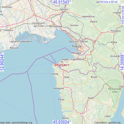
Strunjan GPS coordinates[2]
45° 31' 30" North, 13° 36' 20.016" East
| Map corner | latitude | longitude |
|---|---|---|
| Upper-left | 46.01545°, | 12.90244° |
| Center: | 45.525°, | 13.60556° |
| Lower-right: | 45.03024°, | 14.30869° |
| Map W x H: | 109.5×109.5 km | = 68×68mi |
| max Lat: | 46.83694° ⇑97.5% North |
| Strunjan: | 45.525° |
| min Lat: | ⇓2.5% South 45.47667° |
| min Long | Strunjan | max Long |
| 13.52639° | 13.60556° | 16.4975° |
| W 1%⇐ | ⇒99% E |
Elevation
Elevation of Strunjan is 6 m = 20 ft, and this is 319.6 m = 1049 ft below average elevation for this country.
| Max E: |
1551 m = 5089 ft | 99.7% |
| Avg. | 325.6 m = 1068 ft | |
| Strunjan | 6 m = 20 ft | |
Min E: |
2 m = 7 ft | 0.3% |
See also: Slovenia elevation on elevation.city.
Geographical zone
Strunjan is located in North temperate zone (between Tropic of Cancer and the Arctic Circle). Distance of this North polar circle is 2339.3 km =1453.6 mi to North.| Distance of | km | miles | from Strunjan |
|---|---|---|---|
| North Pole | 4945.2 | 3072.8 | to North |
| Arctic Circle | 2339.3 | 1453.6 | to North |
| Tropic Cancer | 2456 | 1526.1 | to South |
| Equator | 5061.9 | 3145.3 | to South |


Nearby cities:
15 places around Strunjan: (largest is in red/bold)
• Bošamarin
10.2 km =6.3 mi,  92°
92°
• Gažon
7.5 km =4.7 mi,  95°
95°
• Izola
4.6 km =2.9 mi,  73°
73°
• Jagodje
3.3 km =2.1 mi,  83°
83°
• Koper
10 km =6.2 mi, 75°
• Korte
6.3 km =3.9 mi,  127°
127°
• Lucija
2.2 km =1.4 mi,  186°
186°
• Parecag
4.8 km =3 mi,  173°
173°
• Piran
2.7 km =1.7 mi,  276°
276°
• Portorož
1.6 km =1 mi,  221°
221°
• Seča
3.3 km =2.1 mi, 167°
• Sečovlje
5.5 km =3.4 mi, 165°
• Šalara
8.8 km =5.5 mi, 94°
• Šared
4.1 km =2.5 mi,  112°
112°
• Šmarje
9.1 km =5.7 mi, 106°
Sources, notices
• [Note1] Compared only with cities in Slovenia existing in our database
• [Src1] Map data: © OpenStreetMap contributors (CC-BY-SA)
• [Src2] Other city data from geonames.org with taken over terms of usage.
• [Src3] Geographical zone / Annual Mean Temperature by Robert A. Rohde @ Wikipedia
