Seča geodata
Seča (Piran-Pirano) is a populated place; located in Slovenia in Europe/Ljubljana (GMT+2) time zone. With population of 1,210 people, there are 180 cities with bigger population in this country. Compared to other cities in Slovenia, 99.5% of cities are located further ↑North; 98.3% of cities are located further →East and 98.8% of cities have higher elevation than Seča. Note1


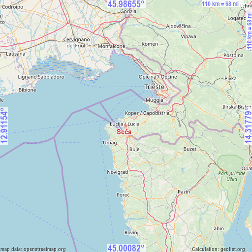
Seča GPS coordinates[2]
45° 29' 45.024" North, 13° 36' 52.776" East
| Map corner | latitude | longitude |
|---|---|---|
| Upper-left | 45.98655°, | 12.91154° |
| Center: | 45.49584°, | 13.61466° |
| Lower-right: | 45.00082°, | 14.31779° |
| Map W x H: | 109.6×109.6 km | = 68.1×68.1mi |
| max Lat: | 46.83694° ⇑99.5% North |
| Seča: | 45.49584° |
| min Lat: | ⇓0.5% South 45.47667° |
| min Long | Seča | max Long |
| 13.52639° | 13.61466° | 16.4975° |
| W 1.7%⇐ | ⇒98.3% E |
Elevation
Elevation of Seča is 17 m = 56 ft, and this is 308.6 m = 1012 ft below average elevation for this country.
| Max E: |
1551 m = 5089 ft | 98.8% |
| Avg. | 325.6 m = 1068 ft | |
| Seča | 17 m = 56 ft | |
Min E: |
2 m = 7 ft | 1.2% |
See also: Slovenia elevation on elevation.city.
Geographical zone
Seča is located in North temperate zone (between Tropic of Cancer and the Arctic Circle). Distance of this North polar circle is 2342.5 km =1455.6 mi to North.| Distance of | km | miles | from Seča |
|---|---|---|---|
| North Pole | 4948.4 | 3074.8 | to North |
| Arctic Circle | 2342.5 | 1455.6 | to North |
| Tropic Cancer | 2452.7 | 1524 | to South |
| Equator | 5058.7 | 3143.3 | to South |


Nearby cities:
15 places around Seča: (largest is in red/bold)
• Bošamarin
9.8 km =6.1 mi,  73°
73°
• Gažon
7.2 km =4.5 mi, 69°
• Izola
5.9 km =3.7 mi,  38°
38°
• Jagodje
4.4 km =2.7 mi,  34°
34°
• Kampel
10.4 km =6.5 mi,  78°
78°
• Korte
4.4 km =2.7 mi,  97°
97°
• Lucija
1.4 km =0.9 mi,  317°
317°
• Parecag
1.5 km =0.9 mi,  184°
184°
• Piran
4.9 km =3 mi, 315°
• Portorož
2.7 km =1.7 mi, 319°
• Sečovlje
2.2 km =1.4 mi,  162°
162°
• Strunjan
3.3 km =2.1 mi,  347°
347°
• Šalara
8.4 km =5.2 mi, 72°
• Šared
3.5 km =2.2 mi,  60°
60°
• Šmarje
8.1 km =5 mi,  85°
85°
Sources, notices
• [Note1] Compared only with cities in Slovenia existing in our database
• [Src1] Map data: © OpenStreetMap contributors (CC-BY-SA)
• [Src2] Other city data from geonames.org with taken over terms of usage.
• [Src3] Geographical zone / Annual Mean Temperature by Robert A. Rohde @ Wikipedia
