Parecag geodata
Parecag (Piran-Pirano) is a populated place; located in Slovenia in Europe/Ljubljana (GMT+2) time zone. With population of 986 people, there are 222 cities with bigger population in this country. Compared to other cities in Slovenia, 99.8% of cities are located further ↑North; 98.7% of cities are located further →East and 98.7% of cities have higher elevation than Parecag. Note1


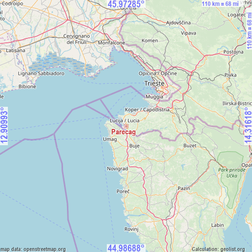
Parecag GPS coordinates[2]
45° 28' 55.272" North, 13° 36' 46.98" East
| Map corner | latitude | longitude |
|---|---|---|
| Upper-left | 45.97285°, | 12.90993° |
| Center: | 45.48202°, | 13.61305° |
| Lower-right: | 44.98688°, | 14.31618° |
| Map W x H: | 109.6×109.6 km | = 68.1×68.1mi |
| max Lat: | 46.83694° ⇑99.8% North |
| Parecag: | 45.48202° |
| min Lat: | ⇓0.2% South 45.47667° |
| min Long | Parecag | max Long |
| 13.52639° | 13.61305° | 16.4975° |
| W 1.3%⇐ | ⇒98.7% E |
Elevation
Elevation of Parecag is 18 m = 59 ft, and this is 307.6 m = 1009 ft below average elevation for this country.
| Max E: |
1551 m = 5089 ft | 98.7% |
| Avg. | 325.6 m = 1068 ft | |
| Parecag | 18 m = 59 ft | |
Min E: |
2 m = 7 ft | 1.3% |
See also: Slovenia elevation on elevation.city.
Geographical zone
Parecag is located in North temperate zone (between Tropic of Cancer and the Arctic Circle). Distance of this North polar circle is 2344 km =1456.5 mi to North.| Distance of | km | miles | from Parecag |
|---|---|---|---|
| North Pole | 4949.9 | 3075.7 | to North |
| Arctic Circle | 2344 | 1456.5 | to North |
| Tropic Cancer | 2451.2 | 1523.1 | to South |
| Equator | 5057.1 | 3142.3 | to South |


Nearby cities:
15 places around Parecag: (largest is in red/bold)
• Bošamarin
10.5 km =6.5 mi,  66°
66°
• Gažon
8 km =5 mi,  59°
59°
• Izola
7.2 km =4.5 mi,  31°
31°
• Jagodje
5.8 km =3.6 mi, 27°
• Kampel
10.9 km =6.8 mi, 71°
• Korte
4.6 km =2.9 mi,  78°
78°
• Lucija
2.7 km =1.7 mi,  342°
342°
• Piran
6.1 km =3.8 mi,  326°
326°
• Portorož
3.9 km =2.4 mi, 335°
• Seča
1.5 km =0.9 mi,  4°
4°
• Sečovlje
1 km =0.6 mi,  126°
126°
• Strunjan
4.8 km =3 mi,  353°
353°
• Šalara
9.1 km =5.7 mi, 63°
• Šared
4.5 km =2.8 mi,  44°
44°
• Šmarje
8.4 km =5.2 mi, 75°
Sources, notices
• [Note1] Compared only with cities in Slovenia existing in our database
• [Src1] Map data: © OpenStreetMap contributors (CC-BY-SA)
• [Src2] Other city data from geonames.org with taken over terms of usage.
• [Src3] Geographical zone / Annual Mean Temperature by Robert A. Rohde @ Wikipedia
