Središče ob Dravi geodata
Središče ob Dravi is a seat of a first-order administrative division; located in Slovenia in Europe/Ljubljana (GMT+2) time zone. With population of 1,124 people, there are 192 cities with bigger population in this country. Compared to other cities in Slovenia, 66% of cities are located further ↓South; 96% of cities are located further ←West and 84.7% of cities have higher elevation than Središče ob Dravi. Note1


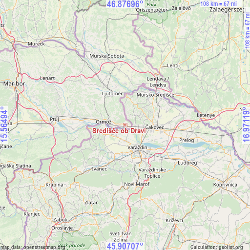
Središče ob Dravi GPS coordinates[2]
46° 23' 39.012" North, 16° 16' 5.016" East
| Map corner | latitude | longitude |
|---|---|---|
| Upper-left | 46.87696°, | 15.56494° |
| Center: | 46.39417°, | 16.26806° |
| Lower-right: | 45.90707°, | 16.97119° |
| Map W x H: | 107.8×107.8 km | = 67×67mi |
| max Lat: | 46.83694° ⇑34% North |
| Središče ob Dravi: | 46.39417° |
| min Lat: | ⇓66% South 45.47667° |
| min Long | Središče ob D | max Long |
| 13.52639° | 16.26806° | 16.4975° |
| W 96%⇐ | ⇒4% E |
Elevation
Elevation of Središče ob Dravi is 182 m = 597 ft, and this is 143.6 m = 471 ft below average elevation for this country.
| Max E: |
1551 m = 5089 ft | 84.7% |
| Avg. | 325.6 m = 1068 ft | |
| Središče ob Dravi | 182 m = 597 ft | |
Min E: |
2 m = 7 ft | 15.3% |
See also: Slovenia elevation on elevation.city.
Geographical zone
Središče ob Dravi is located in North temperate zone (between Tropic of Cancer and the Arctic Circle). Distance of this North polar circle is 2242.6 km =1393.5 mi to North.| Distance of | km | miles | from Središče ob Dravi |
|---|---|---|---|
| North Pole | 4848.5 | 3012.7 | to North |
| Arctic Circle | 2242.6 | 1393.5 | to North |
| Tropic Cancer | 2552.6 | 1586.1 | to South |
| Equator | 5158.5 | 3205.3 | to South |


Nearby cities:
15 places around Središče ob Dravi: (largest is in red/bold)
• Cven
17.4 km =10.8 mi,  347°
347°
• Dolnja Bistrica
16.3 km =10.1 mi,  5°
5°
• Gornja Bistrica
19.2 km =11.9 mi,  359°
359°
• Hotiza
18.7 km =11.6 mi,  22°
22°
• Ljutomer
15.1 km =9.4 mi,  339°
339°
• Lukavci
18.8 km =11.7 mi,  331°
331°
• Mihovci pri Vel. Nedelji
12.1 km =7.5 mi,  276°
276°
• Obrež
2.8 km =1.7 mi, 282°
• Ormož
8.9 km =5.5 mi, 282°
• Podgorci
16.1 km =10 mi, 283°
• Razkrižje
14.2 km =8.8 mi,  4°
4°
• Sveti Tomaž
17.3 km =10.7 mi,  305°
305°
• Zamušani
18.6 km =11.6 mi, 279°
• Zavrč
16.7 km =10.4 mi,  269°
269°
• Črenšovci
18.4 km =11.4 mi, 8°
Sources, notices
• [Note1] Compared only with cities in Slovenia existing in our database
• [Src1] Map data: © OpenStreetMap contributors (CC-BY-SA)
• [Src2] Other city data from geonames.org with taken over terms of usage.
• [Src3] Geographical zone / Annual Mean Temperature by Robert A. Rohde @ Wikipedia
