Begunje pri Cerknici geodata
Begunje pri Cerknici (Cerknica) is a populated place; located in Slovenia in Europe/Ljubljana (GMT+2) time zone. With population of 658 people, there are 388 cities with bigger population in this country. Compared to other cities in Slovenia, 87.5% of cities are located further ↑North; 72.7% of cities are located further →East and 95.5% of cities have lower elevation than Begunje pri Cerknici. Note1


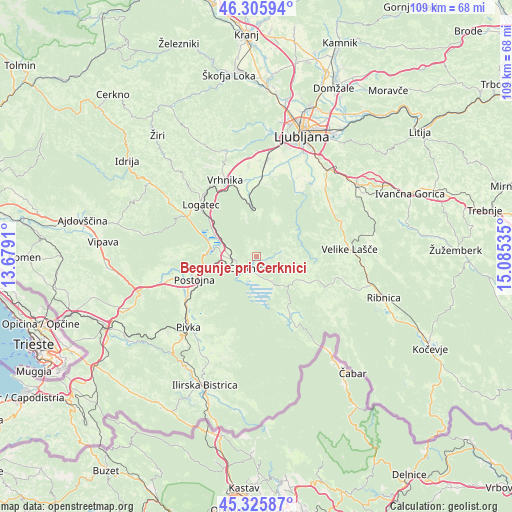
Begunje pri Cerknici GPS coordinates[2]
45° 49' 5.016" North, 14° 22' 55.992" East
| Map corner | latitude | longitude |
|---|---|---|
| Upper-left | 46.30594°, | 13.6791° |
| Center: | 45.81806°, | 14.38222° |
| Lower-right: | 45.32587°, | 15.08535° |
| Map W x H: | 109×109 km | = 67.7×67.7mi |
| max Lat: | 46.83694° ⇑87.5% North |
| Begunje pri Cerknici: | 45.81806° |
| min Lat: | ⇓12.5% South 45.47667° |
| min Long | Begunje pri Cer | max Long |
| 13.52639° | 14.38222° | 16.4975° |
| W 27.3%⇐ | ⇒72.7% E |
Elevation
Elevation of Begunje pri Cerknici is 613 m = 2011 ft, and this is 287.4 m = 943 ft above average elevation for this country.
| Max E: |
1551 m = 5089 ft | 4.5% |
| Begunje pri Cerknici | 613 m 2011 ft | |
| Avg. | 325.6 m = 1068 ft | |
Min E: |
2 m = 7 ft | 95.5% |
See also: Slovenia elevation on elevation.city.
Geographical zone
Begunje pri Cerknici is located in North temperate zone (between Tropic of Cancer and the Arctic Circle). Distance of this North polar circle is 2306.7 km =1433.3 mi to North.| Distance of | km | miles | from Begunje pri Cerknici |
|---|---|---|---|
| North Pole | 4912.6 | 3052.5 | to North |
| Arctic Circle | 2306.7 | 1433.3 | to North |
| Tropic Cancer | 2488.6 | 1546.3 | to South |
| Equator | 5094.5 | 3165.6 | to South |


Nearby cities:
15 places around Begunje pri Cerknici: (largest is in red/bold)
• Borovnica
11 km =6.8 mi,  352°
352°
• Cerknica
3.2 km =2 mi,  208°
208°
• Kalce
17 km =10.6 mi,  300°
300°
• Kamnik pod Krimom
14.4 km =8.9 mi,  7°
7°
• Logatec
16.2 km =10.1 mi,  311°
311°
• Lož
12.4 km =7.7 mi,  147°
147°
• Nova Vas
10.9 km =6.8 mi,  118°
118°
• Planina
10.3 km =6.4 mi,  276°
276°
• Podpeč
17.1 km =10.6 mi, 9°
• Postojna
13.8 km =8.6 mi,  249°
249°
• Rakek
5.5 km =3.4 mi,  264°
264°
• Rakitna
9.2 km =5.7 mi,  31°
31°
• Stari Trg pri Ložu
13.4 km =8.3 mi, 149°
• Unec
6.9 km =4.3 mi,  267°
267°
• Verd
16.5 km =10.3 mi,  339°
339°
Sources, notices
• [Note1] Compared only with cities in Slovenia existing in our database
• [Src1] Map data: © OpenStreetMap contributors (CC-BY-SA)
• [Src2] Other city data from geonames.org with taken over terms of usage.
• [Src3] Geographical zone / Annual Mean Temperature by Robert A. Rohde @ Wikipedia
