Verd geodata
Verd (Vrhnika) is a populated place; located in Slovenia in Europe/Ljubljana (GMT+2) time zone. With population of 1,891 people, there are 110 cities with bigger population in this country. Compared to other cities in Slovenia, 77.3% of cities are located further ↑North; 76.7% of cities are located further →East and 52% of cities have higher elevation than Verd. Note1


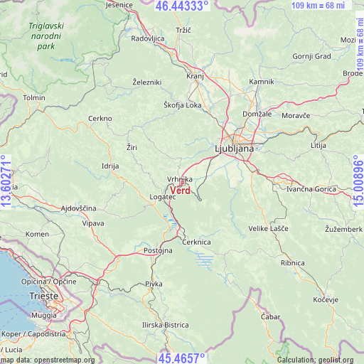
Verd GPS coordinates[2]
45° 57' 24.012" North, 14° 18' 20.988" East
| Map corner | latitude | longitude |
|---|---|---|
| Upper-left | 46.44333°, | 13.60271° |
| Center: | 45.95667°, | 14.30583° |
| Lower-right: | 45.4657°, | 15.00896° |
| Map W x H: | 108.7×108.7 km | = 67.5×67.5mi |
| max Lat: | 46.83694° ⇑77.3% North |
| Verd: | 45.95667° |
| min Lat: | ⇓22.7% South 45.47667° |
| min Long | Verd | max Long |
| 13.52639° | 14.30583° | 16.4975° |
| W 23.3%⇐ | ⇒76.7% E |
Elevation
Elevation of Verd is 293 m = 961 ft, and this is 32.6 m = 107 ft below average elevation for this country.
| Max E: |
1551 m = 5089 ft | 52% |
| Avg. | 325.6 m = 1068 ft | |
| Verd | 293 m = 961 ft | |
Min E: |
2 m = 7 ft | 48% |
See also: Slovenia elevation on elevation.city.
Geographical zone
Verd is located in North temperate zone (between Tropic of Cancer and the Arctic Circle). Distance of this North polar circle is 2291.3 km =1423.7 mi to North.| Distance of | km | miles | from Verd |
|---|---|---|---|
| North Pole | 4897.2 | 3043 | to North |
| Arctic Circle | 2291.3 | 1423.7 | to North |
| Tropic Cancer | 2504 | 1555.9 | to South |
| Equator | 5109.9 | 3175.1 | to South |


Nearby cities:
15 places around Verd: (largest is in red/bold)
• Bevke
4.9 km =3 mi,  51°
51°
• Borovnica
6.3 km =3.9 mi,  135°
135°
• Dragomer
9 km =5.6 mi,  41°
41°
• Drenov Grič
5 km =3.1 mi,  24°
24°
• Horjul
7.5 km =4.7 mi,  356°
356°
• Kamnik pod Krimom
7.9 km =4.9 mi,  98°
98°
• Log pri Brezovici
8.2 km =5.1 mi, 35°
• Logatec
7.8 km =4.8 mi,  232°
232°
• Lukovica pri Brezovici
9.4 km =5.8 mi, 46°
• Notranje Gorice
8 km =5 mi,  64°
64°
• Podpeč
8.8 km =5.5 mi,  80°
80°
• Sinja Gorica
2.3 km =1.4 mi, 24°
• Stara Vrhnika
2.7 km =1.7 mi,  315°
315°
• Vrhnika
1.1 km =0.7 mi,  311°
311°
• Vrzdenec
7.6 km =4.7 mi,  339°
339°
Sources, notices
• [Note1] Compared only with cities in Slovenia existing in our database
• [Src1] Map data: © OpenStreetMap contributors (CC-BY-SA)
• [Src2] Other city data from geonames.org with taken over terms of usage.
• [Src3] Geographical zone / Annual Mean Temperature by Robert A. Rohde @ Wikipedia
