Ptuj geodata
Ptuj is a seat of a first-order administrative division; located in Slovenia in Europe/Ljubljana (GMT+2) time zone. With population of 18,164 people, there are 7 cities with bigger population in this country. Compared to other cities in Slovenia, 70.7% of cities are located further ↓South; 85.3% of cities are located further ←West and 71.7% of cities have higher elevation than Ptuj. Note1


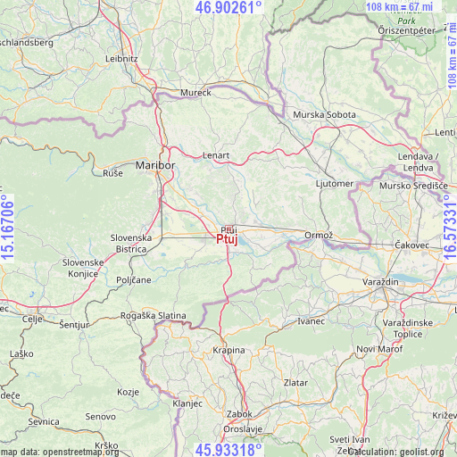
Ptuj GPS coordinates[2]
46° 25' 12.18" North, 15° 52' 12.648" East
| Map corner | latitude | longitude |
|---|---|---|
| Upper-left | 46.90261°, | 15.16706° |
| Center: | 46.42005°, | 15.87018° |
| Lower-right: | 45.93318°, | 16.57331° |
| Map W x H: | 107.8×107.8 km | = 67×67mi |
| max Lat: | 46.83694° ⇑29.3% North |
| Ptuj: | 46.42005° |
| min Lat: | ⇓70.7% South 45.47667° |
| min Long | Ptuj | max Long |
| 13.52639° | 15.87018° | 16.4975° |
| W 85.3%⇐ | ⇒14.7% E |
Elevation
Elevation of Ptuj is 237 m = 778 ft, and this is 88.6 m = 291 ft below average elevation for this country.
| Max E: |
1551 m = 5089 ft | 71.7% |
| Avg. | 325.6 m = 1068 ft | |
| Ptuj | 237 m = 778 ft | |
Min E: |
2 m = 7 ft | 28.3% |
See also: Slovenia elevation on elevation.city.
Geographical zone
Ptuj is located in North temperate zone (between Tropic of Cancer and the Arctic Circle). Distance of this North polar circle is 2239.7 km =1391.7 mi to North.| Distance of | km | miles | from Ptuj |
|---|---|---|---|
| North Pole | 4845.6 | 3010.9 | to North |
| Arctic Circle | 2239.7 | 1391.7 | to North |
| Tropic Cancer | 2555.5 | 1587.9 | to South |
| Equator | 5161.4 | 3207.1 | to South |


Nearby cities:
15 places around Ptuj: (largest is in red/bold)
• Draženci
4.4 km =2.7 mi,  200°
200°
• Gerečja Vas
4.4 km =2.7 mi,  289°
289°
• Hajdoše
3.7 km =2.3 mi, 292°
• Kicar
4.8 km =3 mi,  42°
42°
• Kidričevo
6.3 km =3.9 mi,  253°
253°
• Lancova Vas
5.5 km =3.4 mi,  190°
190°
• Markovci
5.2 km =3.2 mi,  121°
121°
• Mestni Vrh
2.6 km =1.6 mi,  351°
351°
• Njiverce
5.2 km =3.2 mi, 249°
• Pobrežje
4 km =2.5 mi,  170°
170°
• Podvinci
3.8 km =2.4 mi,  68°
68°
• Slovenja Vas
6.3 km =3.9 mi,  301°
301°
• Spodnja Hajdina
2.2 km =1.4 mi,  235°
235°
• Spuhlja
3.5 km =2.2 mi,  103°
103°
• Zgornja Hajdina
2.9 km =1.8 mi, 237°
Sources, notices
• [Note1] Compared only with cities in Slovenia existing in our database
• [Src1] Map data: © OpenStreetMap contributors (CC-BY-SA)
• [Src2] Other city data from geonames.org with taken over terms of usage.
• [Src3] Geographical zone / Annual Mean Temperature by Robert A. Rohde @ Wikipedia
