Kicar geodata
Kicar (Ptuj) is a populated locality; located in Slovenia in Europe/Ljubljana (GMT+2) time zone. With population of 819 people, there are 285 cities with bigger population in this country. Compared to other cities in Slovenia, 74.2% of cities are located further ↓South; 86.8% of cities are located further ←West and 53.8% of cities have higher elevation than Kicar. Note1


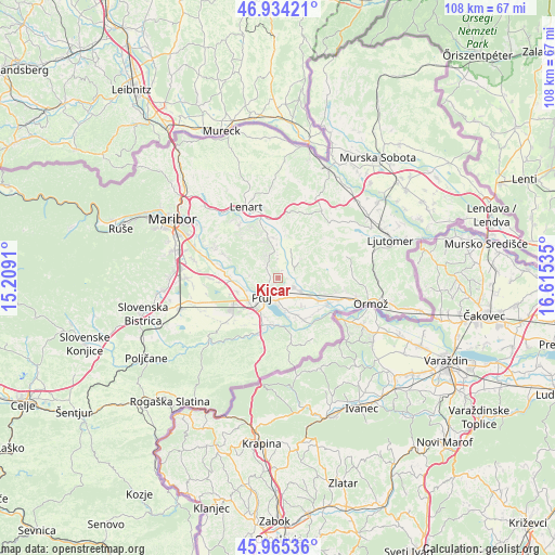
Kicar GPS coordinates[2]
46° 27' 6.984" North, 15° 54' 43.992" East
| Map corner | latitude | longitude |
|---|---|---|
| Upper-left | 46.93421°, | 15.2091° |
| Center: | 46.45194°, | 15.91222° |
| Lower-right: | 45.96536°, | 16.61535° |
| Map W x H: | 107.7×107.7 km | = 66.9×66.9mi |
| max Lat: | 46.83694° ⇑25.8% North |
| Kicar: | 46.45194° |
| min Lat: | ⇓74.2% South 45.47667° |
| min Long | Kicar | max Long |
| 13.52639° | 15.91222° | 16.4975° |
| W 86.8%⇐ | ⇒13.2% E |
Elevation
Elevation of Kicar is 289 m = 948 ft, and this is 36.6 m = 120 ft below average elevation for this country.
| Max E: |
1551 m = 5089 ft | 53.8% |
| Avg. | 325.6 m = 1068 ft | |
| Kicar | 289 m = 948 ft | |
Min E: |
2 m = 7 ft | 46.2% |
See also: Slovenia elevation on elevation.city.
Geographical zone
Kicar is located in North temperate zone (between Tropic of Cancer and the Arctic Circle). Distance of this North polar circle is 2236.2 km =1389.5 mi to North.| Distance of | km | miles | from Kicar |
|---|---|---|---|
| North Pole | 4842.1 | 3008.7 | to North |
| Arctic Circle | 2236.2 | 1389.5 | to North |
| Tropic Cancer | 2559.1 | 1590.2 | to South |
| Equator | 5165 | 3209.4 | to South |


Nearby cities:
15 places around Kicar: (largest is in red/bold)
• Destrnik
5.2 km =3.2 mi,  330°
330°
• Dornava
3.6 km =2.2 mi,  118°
118°
• Gerečja Vas
7.6 km =4.7 mi,  254°
254°
• Hajdoše
6.9 km =4.3 mi, 252°
• Juršinci
5.8 km =3.6 mi,  51°
51°
• Markovci
6.4 km =4 mi,  168°
168°
• Mestni Vrh
3.7 km =2.3 mi,  255°
255°
• Moškanjci
7.1 km =4.4 mi, 119°
• Pobrežje
7.9 km =4.9 mi,  199°
199°
• Podvinci
2.2 km =1.4 mi, 171°
• Ptuj
4.8 km =3 mi,  222°
222°
• Spodnja Hajdina
6.9 km =4.3 mi,  226°
226°
• Spuhlja
4.4 km =2.7 mi,  177°
177°
• Trnovska Vas
7.8 km =4.8 mi,  345°
345°
• Zgornja Hajdina
7.6 km =4.7 mi, 227°
Sources, notices
• [Note1] Compared only with cities in Slovenia existing in our database
• [Src1] Map data: © OpenStreetMap contributors (CC-BY-SA)
• [Src2] Other city data from geonames.org with taken over terms of usage.
• [Src3] Geographical zone / Annual Mean Temperature by Robert A. Rohde @ Wikipedia
