Muta geodata
Muta is a seat of a first-order administrative division; located in Slovenia in Europe/Ljubljana (GMT+2) time zone. With population of 2,300 people, there are 84 cities with bigger population in this country. Compared to other cities in Slovenia, 92.5% of cities are located further ↓South; 58.5% of cities are located further ←West and 61.3% of cities have lower elevation than Muta. Note1


Muta GPS coordinates[2]
46° 36' 41.004" North, 15° 9' 57.996" East
| Map corner | latitude | longitude |
|---|---|---|
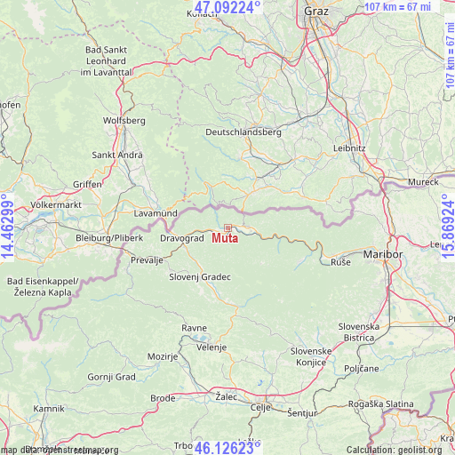
| Upper-left | 47.09224°, | 14.46299° |
| Center: | 46.61139°, | 15.16611° |
| Lower-right: | 46.12623°, | 15.86924° |
| Map W x H: | 107.4×107.4 km | = 66.7×66.7mi |
| max Lat: | 46.83694° ⇑7.5% North |
| Muta: | 46.61139° |
| min Lat: | ⇓92.5% South 45.47667° |
| min Long | Muta | max Long |
| 13.52639° | 15.16611° | 16.4975° |
| W 58.5%⇐ | ⇒41.5% E |
Elevation
Elevation of Muta is 334 m = 1096 ft, and this is 8.4 m = 28 ft above average elevation for this country.
| Max E: |
1551 m = 5089 ft | 38.7% |
| Muta | 334 m 1096 ft | |
| Avg. | 325.6 m = 1068 ft | |
Min E: |
2 m = 7 ft | 61.3% |
See also: Slovenia elevation on elevation.city.
Geographical zone
Muta is located in North temperate zone (between Tropic of Cancer and the Arctic Circle). Distance of this North polar circle is 2218.5 km =1378.5 mi to North.| Distance of | km | miles | from Muta |
|---|---|---|---|
| North Pole | 4824.4 | 2997.7 | to North |
| Arctic Circle | 2218.5 | 1378.5 | to North |
| Tropic Cancer | 2576.8 | 1601.1 | to South |
| Equator | 5182.7 | 3220.4 | to South |


Nearby cities:
15 places around Muta: (largest is in red/bold)
• Dravograd
11.5 km =7.1 mi,  256°
256°
• Gortina
3.1 km =1.9 mi, 258°
• Legen
11.8 km =7.3 mi,  188°
188°
• Otiški Vrh
11 km =6.8 mi,  247°
247°
• Pameče
10.9 km =6.8 mi,  217°
217°
• Podvelka
12.9 km =8 mi,  102°
102°
• Radlje ob Dravi
4.6 km =2.9 mi,  86°
86°
• Ribnica na Pohorju
11.8 km =7.3 mi,  136°
136°
• Slovenj Gradec
13 km =8.1 mi,  210°
210°
• Stari Trg
14.5 km =9 mi, 211°
• Vuhred
5.8 km =3.6 mi,  108°
108°
• Vuzenica
1.7 km =1.1 mi,  177°
177°
• Črneče
12.9 km =8 mi, 258°
• Šentjanž pri Dravogradu
11.2 km =7 mi,  240°
240°
• Šmartno pri Slovenj Gradcu
14.3 km =8.9 mi,  198°
198°
Sources, notices
• [Note1] Compared only with cities in Slovenia existing in our database
• [Src1] Map data: © OpenStreetMap contributors (CC-BY-SA)
• [Src2] Other city data from geonames.org with taken over terms of usage.
• [Src3] Geographical zone / Annual Mean Temperature by Robert A. Rohde @ Wikipedia
