Legen geodata
Legen (Slovenj Gradec) is a populated place; located in Slovenia in Europe/Ljubljana (GMT+2) time zone. With population of 1,026 people, there are 209 cities with bigger population in this country. Compared to other cities in Slovenia, 79.5% of cities are located further ↓South; 57.3% of cities are located further ←West and 98.2% of cities have lower elevation than Legen. Note1


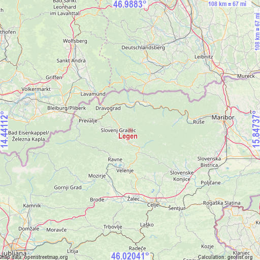
Legen GPS coordinates[2]
46° 30' 23.436" North, 15° 8' 39.264" East
| Map corner | latitude | longitude |
|---|---|---|
| Upper-left | 46.9883°, | 14.44112° |
| Center: | 46.50651°, | 15.14424° |
| Lower-right: | 46.02041°, | 15.84737° |
| Map W x H: | 107.6×107.6 km | = 66.9×66.9mi |
| max Lat: | 46.83694° ⇑20.5% North |
| Legen: | 46.50651° |
| min Lat: | ⇓79.5% South 45.47667° |
| min Long | Legen | max Long |
| 13.52639° | 15.14424° | 16.4975° |
| W 57.3%⇐ | ⇒42.7% E |
Elevation
Elevation of Legen is 828 m = 2717 ft, and this is 502.4 m = 1648 ft above average elevation for this country.
| Max E: |
1551 m = 5089 ft | 1.8% |
| Legen | 828 m 2717 ft | |
| Avg. | 325.6 m = 1068 ft | |
Min E: |
2 m = 7 ft | 98.2% |
See also: Slovenia elevation on elevation.city.
Geographical zone
Legen is located in North temperate zone (between Tropic of Cancer and the Arctic Circle). Distance of this North polar circle is 2230.1 km =1385.7 mi to North.| Distance of | km | miles | from Legen |
|---|---|---|---|
| North Pole | 4836 | 3005 | to North |
| Arctic Circle | 2230.1 | 1385.7 | to North |
| Tropic Cancer | 2565.1 | 1593.9 | to South |
| Equator | 5171 | 3213.1 | to South |


Nearby cities:
15 places around Legen: (largest is in red/bold)
• Brdinje
11.4 km =7.1 mi,  285°
285°
• Gornji Dolič
9.7 km =6 mi,  161°
161°
• Gortina
11.1 km =6.9 mi,  352°
352°
• Mislinja
8.4 km =5.2 mi,  149°
149°
• Mislinjska Dobrava
4.8 km =3 mi,  198°
198°
• Muta
11.8 km =7.3 mi,  8°
8°
• Otiški Vrh
11.3 km =7 mi,  311°
311°
• Pameče
5.9 km =3.7 mi,  301°
301°
• Podgorje
6 km =3.7 mi,  230°
230°
• Ribnica na Pohorju
10.3 km =6.4 mi,  72°
72°
• Slovenj Gradec
4.9 km =3 mi,  274°
274°
• Stari Trg
6 km =3.7 mi,  263°
263°
• Vuzenica
10.1 km =6.3 mi, 9°
• Šentjanž pri Dravogradu
10.1 km =6.3 mi, 306°
• Šmartno pri Slovenj Gradcu
3.4 km =2.1 mi,  236°
236°
Sources, notices
• [Note1] Compared only with cities in Slovenia existing in our database
• [Src1] Map data: © OpenStreetMap contributors (CC-BY-SA)
• [Src2] Other city data from geonames.org with taken over terms of usage.
• [Src3] Geographical zone / Annual Mean Temperature by Robert A. Rohde @ Wikipedia
