Gortina geodata
Gortina (Muta) is a populated place; located in Slovenia in Europe/Ljubljana (GMT+2) time zone. With population of 601 people, there are 438 cities with bigger population in this country. Compared to other cities in Slovenia, 91.5% of cities are located further ↓South; 56.8% of cities are located further ←West and 69.5% of cities have lower elevation than Gortina. Note1


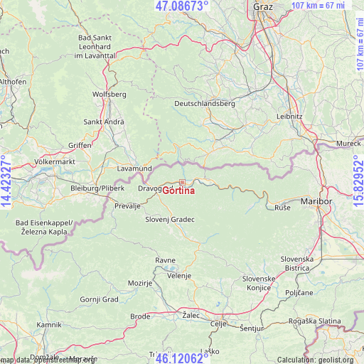
Gortina GPS coordinates[2]
46° 36' 20.988" North, 15° 7' 35.004" East
| Map corner | latitude | longitude |
|---|---|---|
| Upper-left | 47.08673°, | 14.42327° |
| Center: | 46.60583°, | 15.12639° |
| Lower-right: | 46.12062°, | 15.82952° |
| Map W x H: | 107.4×107.4 km | = 66.7×66.7mi |
| max Lat: | 46.83694° ⇑8.5% North |
| Gortina: | 46.60583° |
| min Lat: | ⇓91.5% South 45.47667° |
| min Long | Gortina | max Long |
| 13.52639° | 15.12639° | 16.4975° |
| W 56.8%⇐ | ⇒43.2% E |
Elevation
Elevation of Gortina is 370 m = 1214 ft, and this is 44.4 m = 146 ft above average elevation for this country.
| Max E: |
1551 m = 5089 ft | 30.5% |
| Gortina | 370 m 1214 ft | |
| Avg. | 325.6 m = 1068 ft | |
Min E: |
2 m = 7 ft | 69.5% |
See also: Slovenia elevation on elevation.city.
Geographical zone
Gortina is located in North temperate zone (between Tropic of Cancer and the Arctic Circle). Distance of this North polar circle is 2219.1 km =1378.9 mi to North.| Distance of | km | miles | from Gortina |
|---|---|---|---|
| North Pole | 4825 | 2998.1 | to North |
| Arctic Circle | 2219.1 | 1378.9 | to North |
| Tropic Cancer | 2576.2 | 1600.8 | to South |
| Equator | 5182.1 | 3220 | to South |


Nearby cities:
15 places around Gortina: (largest is in red/bold)
• Brdinje
12.6 km =7.8 mi,  230°
230°
• Dravograd
8.4 km =5.2 mi,  256°
256°
• Legen
11.1 km =6.9 mi,  172°
172°
• Muta
3.1 km =1.9 mi,  78°
78°
• Otiški Vrh
8 km =5 mi,  243°
243°
• Pameče
8.7 km =5.4 mi,  204°
204°
• Radlje ob Dravi
7.7 km =4.8 mi, 83°
• Ribnica na Pohorju
13.7 km =8.5 mi,  125°
125°
• Slovenj Gradec
11.2 km =7 mi, 198°
• Stari Trg
12.6 km =7.8 mi, 201°
• Vuhred
8.6 km =5.3 mi,  98°
98°
• Vuzenica
3.3 km =2.1 mi,  108°
108°
• Črneče
9.8 km =6.1 mi, 258°
• Šentjanž pri Dravogradu
8.3 km =5.2 mi, 233°
• Šmartno pri Slovenj Gradcu
13 km =8.1 mi,  186°
186°
Sources, notices
• [Note1] Compared only with cities in Slovenia existing in our database
• [Src1] Map data: © OpenStreetMap contributors (CC-BY-SA)
• [Src2] Other city data from geonames.org with taken over terms of usage.
• [Src3] Geographical zone / Annual Mean Temperature by Robert A. Rohde @ Wikipedia
