Pragersko geodata
Pragersko (Slovenska Bistrica) is a populated place; located in Slovenia in Europe/Ljubljana (GMT+2) time zone. With population of 1,150 people, there are 188 cities with bigger population in this country. Compared to other cities in Slovenia, 66.3% of cities are located further ↓South; 76.2% of cities are located further ←West and 66.8% of cities have higher elevation than Pragersko. Note1


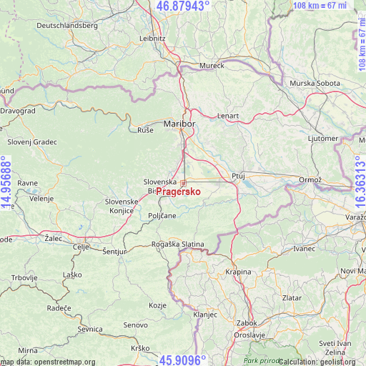
Pragersko GPS coordinates[2]
46° 23' 48.012" North, 15° 39' 36" East
| Map corner | latitude | longitude |
|---|---|---|
| Upper-left | 46.87943°, | 14.95688° |
| Center: | 46.39667°, | 15.66° |
| Lower-right: | 45.9096°, | 16.36313° |
| Map W x H: | 107.8×107.8 km | = 67×67mi |
| max Lat: | 46.83694° ⇑33.7% North |
| Pragersko: | 46.39667° |
| min Lat: | ⇓66.3% South 45.47667° |
| min Long | Pragersko | max Long |
| 13.52639° | 15.66° | 16.4975° |
| W 76.2%⇐ | ⇒23.8% E |
Elevation
Elevation of Pragersko is 250 m = 820 ft, and this is 75.6 m = 248 ft below average elevation for this country.
| Max E: |
1551 m = 5089 ft | 66.8% |
| Avg. | 325.6 m = 1068 ft | |
| Pragersko | 250 m = 820 ft | |
Min E: |
2 m = 7 ft | 33.2% |
See also: Slovenia elevation on elevation.city.
Geographical zone
Pragersko is located in North temperate zone (between Tropic of Cancer and the Arctic Circle). Distance of this North polar circle is 2242.3 km =1393.3 mi to North.| Distance of | km | miles | from Pragersko |
|---|---|---|---|
| North Pole | 4848.2 | 3012.5 | to North |
| Arctic Circle | 2242.3 | 1393.3 | to North |
| Tropic Cancer | 2552.9 | 1586.3 | to South |
| Equator | 5158.8 | 3205.5 | to South |


Nearby cities:
15 places around Pragersko: (largest is in red/bold)
• Fram
7 km =4.3 mi,  340°
340°
• Gabernik
6 km =3.7 mi,  302°
302°
• Gaj
1.4 km =0.9 mi,  44°
44°
• Hotinja Vas
7.8 km =4.8 mi,  3°
3°
• Kovača Vas
7.9 km =4.9 mi,  281°
281°
• Leskovec
2.5 km =1.6 mi,  234°
234°
• Majšperk
7.5 km =4.7 mi,  131°
131°
• Makole
8.9 km =5.5 mi,  176°
176°
• Morje
6.1 km =3.8 mi,  330°
330°
• Radizel
8.7 km =5.4 mi,  357°
357°
• Rače
6.4 km =4 mi,  14°
14°
• Slovenska Bistrica
6.6 km =4.1 mi,  266°
266°
• Spodnja Polskava
2.2 km =1.4 mi,  313°
313°
• Zgornja Polskava
4.9 km =3 mi, 311°
• Črešnjevec
4.1 km =2.5 mi,  235°
235°
Sources, notices
• [Note1] Compared only with cities in Slovenia existing in our database
• [Src1] Map data: © OpenStreetMap contributors (CC-BY-SA)
• [Src2] Other city data from geonames.org with taken over terms of usage.
• [Src3] Geographical zone / Annual Mean Temperature by Robert A. Rohde @ Wikipedia
