Majšperk geodata
Majšperk is a seat of a first-order administrative division; located in Slovenia in Europe/Ljubljana (GMT+2) time zone. With population of 637 people, there are 404 cities with bigger population in this country. Compared to other cities in Slovenia, 60.3% of cities are located further ↓South; 80% of cities are located further ←West and 55.7% of cities have higher elevation than Majšperk. Note1


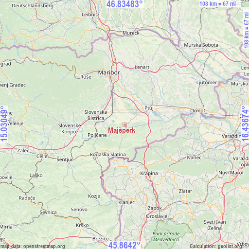
Majšperk GPS coordinates[2]
46° 21' 6.012" North, 15° 44' 0.996" East
| Map corner | latitude | longitude |
|---|---|---|
| Upper-left | 46.83483°, | 15.03049° |
| Center: | 46.35167°, | 15.73361° |
| Lower-right: | 45.8642°, | 16.43674° |
| Map W x H: | 107.9×107.9 km | = 67×67mi |
| max Lat: | 46.83694° ⇑39.7% North |
| Majšperk: | 46.35167° |
| min Lat: | ⇓60.3% South 45.47667° |
| min Long | Majšperk | max Long |
| 13.52639° | 15.73361° | 16.4975° |
| W 80%⇐ | ⇒20% E |
Elevation
Elevation of Majšperk is 283 m = 928 ft, and this is 42.6 m = 140 ft below average elevation for this country.
| Max E: |
1551 m = 5089 ft | 55.7% |
| Avg. | 325.6 m = 1068 ft | |
| Majšperk | 283 m = 928 ft | |
Min E: |
2 m = 7 ft | 44.3% |
See also: Slovenia elevation on elevation.city.
Geographical zone
Majšperk is located in North temperate zone (between Tropic of Cancer and the Arctic Circle). Distance of this North polar circle is 2247.4 km =1396.5 mi to North.| Distance of | km | miles | from Majšperk |
|---|---|---|---|
| North Pole | 4853.2 | 3015.6 | to North |
| Arctic Circle | 2247.4 | 1396.5 | to North |
| Tropic Cancer | 2547.9 | 1583.2 | to South |
| Equator | 5153.8 | 3202.4 | to South |


Nearby cities:
15 places around Majšperk: (largest is in red/bold)
• Apače
6 km =3.7 mi,  62°
62°
• Draženci
9.6 km =6 mi,  68°
68°
• Gaj
7.6 km =4.7 mi,  321°
321°
• Kidričevo
7.3 km =4.5 mi,  37°
37°
• Lancova Vas
9.7 km =6 mi,  77°
77°
• Leskovec
8.5 km =5.3 mi,  294°
294°
• Lovrenc na Dravskem Polju
4.3 km =2.7 mi, 55°
• Makole
6.4 km =4 mi,  233°
233°
• Njiverce
8.1 km =5 mi, 44°
• Pragersko
7.5 km =4.7 mi,  311°
311°
• Prepolje
10.5 km =6.5 mi,  12°
12°
• Spodnja Hajdina
10.8 km =6.7 mi,  53°
53°
• Spodnja Polskava
9.8 km =6.1 mi, 312°
• Zgornja Hajdina
10.1 km =6.3 mi, 53°
• Črešnjevec
9.4 km =5.8 mi, 286°
Sources, notices
• [Note1] Compared only with cities in Slovenia existing in our database
• [Src1] Map data: © OpenStreetMap contributors (CC-BY-SA)
• [Src2] Other city data from geonames.org with taken over terms of usage.
• [Src3] Geographical zone / Annual Mean Temperature by Robert A. Rohde @ Wikipedia
