Makole geodata
Makole is a seat of a first-order administrative division; located in Slovenia in Europe/Ljubljana (GMT+2) time zone. With population of 250 people, there are 587 cities with bigger population in this country. Compared to other cities in Slovenia, 56.7% of cities are located further ↓South; 76.8% of cities are located further ←West and 64.7% of cities have higher elevation than Makole. Note1


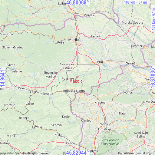
Makole GPS coordinates[2]
46° 19' 1.992" North, 15° 40' 1.992" East
| Map corner | latitude | longitude |
|---|---|---|
| Upper-left | 46.80069°, | 14.9641° |
| Center: | 46.31722°, | 15.66722° |
| Lower-right: | 45.82944°, | 16.37035° |
| Map W x H: | 108×108 km | = 67.1×67.1mi |
| max Lat: | 46.83694° ⇑43.3% North |
| Makole: | 46.31722° |
| min Lat: | ⇓56.7% South 45.47667° |
| min Long | Makole | max Long |
| 13.52639° | 15.66722° | 16.4975° |
| W 76.8%⇐ | ⇒23.2% E |
Elevation
Elevation of Makole is 260 m = 853 ft, and this is 65.6 m = 215 ft below average elevation for this country.
| Max E: |
1551 m = 5089 ft | 64.7% |
| Avg. | 325.6 m = 1068 ft | |
| Makole | 260 m = 853 ft | |
Min E: |
2 m = 7 ft | 35.3% |
See also: Slovenia elevation on elevation.city.
Geographical zone
Makole is located in North temperate zone (between Tropic of Cancer and the Arctic Circle). Distance of this North polar circle is 2251.2 km =1398.8 mi to North.| Distance of | km | miles | from Makole |
|---|---|---|---|
| North Pole | 4857.1 | 3018.1 | to North |
| Arctic Circle | 2251.2 | 1398.8 | to North |
| Tropic Cancer | 2544.1 | 1580.8 | to South |
| Equator | 5150 | 3200.1 | to South |


Nearby cities:
15 places around Makole: (largest is in red/bold)
• Apače
12.3 km =7.6 mi,  57°
57°
• Gaj
9.8 km =6.1 mi,  2°
2°
• Leskovec
7.8 km =4.8 mi,  340°
340°
• Lovrenc na Dravskem Polju
10.6 km =6.6 mi,  53°
53°
• Majšperk
6.4 km =4 mi, 53°
• Poljčane
6.8 km =4.2 mi,  265°
265°
• Pragersko
8.9 km =5.5 mi,  356°
356°
• Rogatec
10.1 km =6.3 mi,  165°
165°
• Rogaška Slatina
9.1 km =5.7 mi,  193°
193°
• Slovenska Bistrica
11 km =6.8 mi,  319°
319°
• Spodnja Polskava
10.6 km =6.6 mi,  348°
348°
• Spodnje Poljčane
6 km =3.7 mi, 267°
• Zgornja Polskava
12.8 km =8 mi, 340°
• Zgornje Poljčane
6.7 km =4.2 mi,  255°
255°
• Črešnjevec
7.6 km =4.7 mi,  329°
329°
Sources, notices
• [Note1] Compared only with cities in Slovenia existing in our database
• [Src1] Map data: © OpenStreetMap contributors (CC-BY-SA)
• [Src2] Other city data from geonames.org with taken over terms of usage.
• [Src3] Geographical zone / Annual Mean Temperature by Robert A. Rohde @ Wikipedia
