Apače geodata
Apače (Kidričevo) is a populated place; located in Slovenia in Europe/Ljubljana (GMT+2) time zone. With population of 802 people, there are 296 cities with bigger population in this country. Compared to other cities in Slovenia, 63% of cities are located further ↓South; 82.7% of cities are located further ←West and 72.7% of cities have higher elevation than Apače. Note1


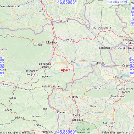
Apače GPS coordinates[2]
46° 22' 36.984" North, 15° 48' 9" East
| Map corner | latitude | longitude |
|---|---|---|
| Upper-left | 46.85988°, | 15.09938° |
| Center: | 46.37694°, | 15.8025° |
| Lower-right: | 45.88969°, | 16.50563° |
| Map W x H: | 107.9×107.9 km | = 67×67mi |
| max Lat: | 46.83694° ⇑37% North |
| Apače: | 46.37694° |
| min Lat: | ⇓63% South 45.47667° |
| min Long | Apače | max Long |
| 13.52639° | 15.8025° | 16.4975° |
| W 82.7%⇐ | ⇒17.3% E |
Elevation
Elevation of Apače is 235 m = 771 ft, and this is 90.6 m = 297 ft below average elevation for this country.
| Max E: |
1551 m = 5089 ft | 72.7% |
| Avg. | 325.6 m = 1068 ft | |
| Apače | 235 m = 771 ft | |
Min E: |
2 m = 7 ft | 27.3% |
See also: Slovenia elevation on elevation.city.
Geographical zone
Apače is located in North temperate zone (between Tropic of Cancer and the Arctic Circle). Distance of this North polar circle is 2244.5 km =1394.7 mi to North.| Distance of | km | miles | from Apače |
|---|---|---|---|
| North Pole | 4850.4 | 3013.9 | to North |
| Arctic Circle | 2244.5 | 1394.7 | to North |
| Tropic Cancer | 2550.7 | 1584.9 | to South |
| Equator | 5156.6 | 3204.2 | to South |


Nearby cities:
15 places around Apače: (largest is in red/bold)
• Draženci
3.7 km =2.3 mi,  78°
78°
• Gerečja Vas
6.4 km =4 mi,  9°
9°
• Hajdoše
6.5 km =4 mi,  16°
16°
• Kidričevo
3.1 km =1.9 mi,  343°
343°
• Lancova Vas
4.2 km =2.6 mi,  98°
98°
• Lovrenc na Dravskem Polju
1.8 km =1.1 mi,  258°
258°
• Majšperk
6 km =3.7 mi,  242°
242°
• Njiverce
3 km =1.9 mi, 6°
• Pobrežje
5.9 km =3.7 mi, 81°
• Podlehnik
7.5 km =4.7 mi,  127°
127°
• Prepolje
8 km =5 mi, 338°
• Ptuj
7.1 km =4.4 mi,  47°
47°
• Spodnja Hajdina
4.9 km =3 mi,  43°
43°
• Videm pri Ptuju
8 km =5 mi, 96°
• Zgornja Hajdina
4.3 km =2.7 mi, 40°
Sources, notices
• [Note1] Compared only with cities in Slovenia existing in our database
• [Src1] Map data: © OpenStreetMap contributors (CC-BY-SA)
• [Src2] Other city data from geonames.org with taken over terms of usage.
• [Src3] Geographical zone / Annual Mean Temperature by Robert A. Rohde @ Wikipedia
