Ceršak geodata
Ceršak (Šentilj) is a populated place; located in Slovenia in Europe/Ljubljana (GMT+2) time zone. With population of 708 people, there are 352 cities with bigger population in this country. Compared to other cities in Slovenia, 98.5% of cities are located further ↓South; 77% of cities are located further ←West and 55.7% of cities have lower elevation than Ceršak. Note1


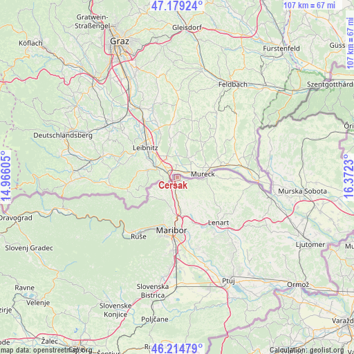
Ceršak GPS coordinates[2]
46° 41' 57.012" North, 15° 40' 9.012" East
| Map corner | latitude | longitude |
|---|---|---|
| Upper-left | 47.17924°, | 14.96605° |
| Center: | 46.69917°, | 15.66917° |
| Lower-right: | 46.21479°, | 16.3723° |
| Map W x H: | 107.2×107.2 km | = 66.6×66.6mi |
| max Lat: | 46.83694° ⇑1.5% North |
| Ceršak: | 46.69917° |
| min Lat: | ⇓98.5% South 45.47667° |
| min Long | Ceršak | max Long |
| 13.52639° | 15.66917° | 16.4975° |
| W 77%⇐ | ⇒23% E |
Elevation
Elevation of Ceršak is 312 m = 1024 ft, and this is 13.6 m = 45 ft below average elevation for this country.
| Max E: |
1551 m = 5089 ft | 44.3% |
| Avg. | 325.6 m = 1068 ft | |
| Ceršak | 312 m = 1024 ft | |
Min E: |
2 m = 7 ft | 55.7% |
See also: Slovenia elevation on elevation.city.
Geographical zone
Ceršak is located in North temperate zone (between Tropic of Cancer and the Arctic Circle). Distance of this North polar circle is 2208.7 km =1372.4 mi to North.| Distance of | km | miles | from Ceršak |
|---|---|---|---|
| North Pole | 4814.6 | 2991.7 | to North |
| Arctic Circle | 2208.7 | 1372.4 | to North |
| Tropic Cancer | 2586.5 | 1607.2 | to South |
| Equator | 5192.5 | 3226.5 | to South |


Nearby cities:
15 places around Ceršak: (largest is in red/bold)
• Gačnik
9.5 km =5.9 mi,  165°
165°
• Gradiška
9.2 km =5.7 mi,  190°
190°
• Jurovski Dol
13.6 km =8.5 mi,  139°
139°
• Kamnica
14.5 km =9 mi,  196°
196°
• Kozjak nad Pesnico
10.3 km =6.4 mi, 194°
• Pesnica pri Mariboru
10.3 km =6.4 mi,  176°
176°
• Plintovec
7.8 km =4.8 mi,  209°
209°
• Selnica ob Muri
2.9 km =1.8 mi,  126°
126°
• Sladki Vrh
5.3 km =3.3 mi,  102°
102°
• Sv. Ana v Slov. Goricah
14.5 km =9 mi,  112°
112°
• Zgornja Kungota
7.8 km =4.8 mi, 211°
• Zgornja Velka
8.1 km =5 mi, 109°
• Zgornja Ščavnica
13.9 km =8.6 mi, 109°
• Zgornje Partinje
13.4 km =8.3 mi,  149°
149°
• Šentilj v Slov. Goricah
2.5 km =1.6 mi,  219°
219°
Sources, notices
• [Note1] Compared only with cities in Slovenia existing in our database
• [Src1] Map data: © OpenStreetMap contributors (CC-BY-SA)
• [Src2] Other city data from geonames.org with taken over terms of usage.
• [Src3] Geographical zone / Annual Mean Temperature by Robert A. Rohde @ Wikipedia
