Gradiška geodata
Gradiška (Kungota) is a populated place; located in Slovenia in Europe/Ljubljana (GMT+2) time zone. With population of 929 people, there are 237 cities with bigger population in this country. Compared to other cities in Slovenia, 93.2% of cities are located further ↓South; 75.3% of cities are located further ←West and 62.8% of cities have higher elevation than Gradiška. Note1


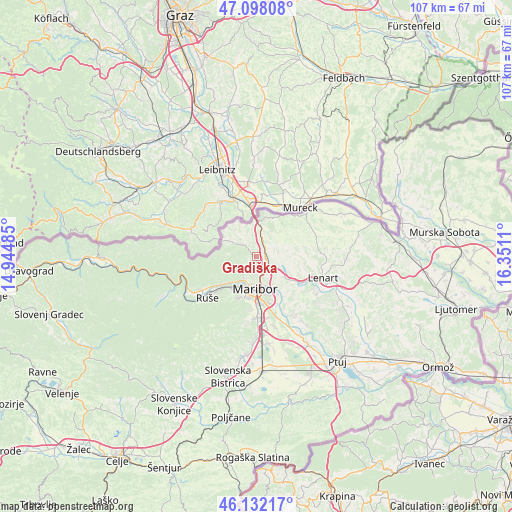
Gradiška GPS coordinates[2]
46° 37' 2.208" North, 15° 38' 52.692" East
| Map corner | latitude | longitude |
|---|---|---|
| Upper-left | 47.09808°, | 14.94485° |
| Center: | 46.61728°, | 15.64797° |
| Lower-right: | 46.13217°, | 16.3511° |
| Map W x H: | 107.4×107.4 km | = 66.7×66.7mi |
| max Lat: | 46.83694° ⇑6.8% North |
| Gradiška: | 46.61728° |
| min Lat: | ⇓93.2% South 45.47667° |
| min Long | Gradiška | max Long |
| 13.52639° | 15.64797° | 16.4975° |
| W 75.3%⇐ | ⇒24.7% E |
Elevation
Elevation of Gradiška is 264 m = 866 ft, and this is 61.6 m = 202 ft below average elevation for this country.
| Max E: |
1551 m = 5089 ft | 62.8% |
| Avg. | 325.6 m = 1068 ft | |
| Gradiška | 264 m = 866 ft | |
Min E: |
2 m = 7 ft | 37.2% |
See also: Slovenia elevation on elevation.city.
Geographical zone
Gradiška is located in North temperate zone (between Tropic of Cancer and the Arctic Circle). Distance of this North polar circle is 2217.8 km =1378.1 mi to North.| Distance of | km | miles | from Gradiška |
|---|---|---|---|
| North Pole | 4823.7 | 2997.3 | to North |
| Arctic Circle | 2217.8 | 1378.1 | to North |
| Tropic Cancer | 2577.4 | 1601.5 | to South |
| Equator | 5183.4 | 3220.8 | to South |


Nearby cities:
15 places around Gradiška: (largest is in red/bold)
• Bresternica
7.7 km =4.8 mi,  226°
226°
• Gačnik
4 km =2.5 mi,  90°
90°
• Kamnica
5.4 km =3.4 mi,  208°
208°
• Kozjak nad Pesnico
1.3 km =0.8 mi, 231°
• Limbuš
8.6 km =5.3 mi, 214°
• Malečnik
8.2 km =5.1 mi,  149°
149°
• Maribor
7 km =4.3 mi,  180°
180°
• Pekre
8.8 km =5.5 mi, 207°
• Pesnica pri Mariboru
2.5 km =1.6 mi,  117°
117°
• Plintovec
3.2 km =2 mi,  315°
315°
• Selnica ob Muri
8.3 km =5.2 mi,  28°
28°
• Zgornja Kungota
3.5 km =2.2 mi,  314°
314°
• Zgornje Partinje
8.8 km =5.5 mi,  105°
105°
• Zrkovci
9 km =5.6 mi, 149°
• Šentilj v Slov. Goricah
7.2 km =4.5 mi,  0°
0°
Sources, notices
• [Note1] Compared only with cities in Slovenia existing in our database
• [Src1] Map data: © OpenStreetMap contributors (CC-BY-SA)
• [Src2] Other city data from geonames.org with taken over terms of usage.
• [Src3] Geographical zone / Annual Mean Temperature by Robert A. Rohde @ Wikipedia
