Plintovec geodata
Plintovec (Kungota) is a populated place; located in Slovenia in Europe/Ljubljana (GMT+2) time zone. With population of 669 people, there are 379 cities with bigger population in this country. Compared to other cities in Slovenia, 94.3% of cities are located further ↓South; 73.3% of cities are located further ←West and 60% of cities have higher elevation than Plintovec. Note1


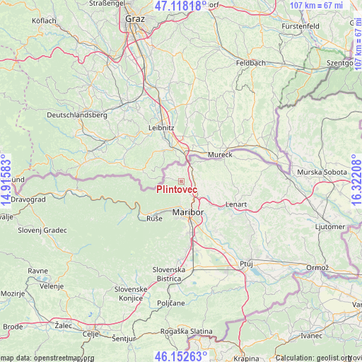
Plintovec GPS coordinates[2]
46° 38' 15.216" North, 15° 37' 8.22" East
| Map corner | latitude | longitude |
|---|---|---|
| Upper-left | 47.11818°, | 14.91583° |
| Center: | 46.63756°, | 15.61895° |
| Lower-right: | 46.15263°, | 16.32208° |
| Map W x H: | 107.4×107.4 km | = 66.7×66.7mi |
| max Lat: | 46.83694° ⇑5.7% North |
| Plintovec: | 46.63756° |
| min Lat: | ⇓94.3% South 45.47667° |
| min Long | Plintovec | max Long |
| 13.52639° | 15.61895° | 16.4975° |
| W 73.3%⇐ | ⇒26.7% E |
Elevation
Elevation of Plintovec is 272 m = 892 ft, and this is 53.6 m = 176 ft below average elevation for this country.
| Max E: |
1551 m = 5089 ft | 60% |
| Avg. | 325.6 m = 1068 ft | |
| Plintovec | 272 m = 892 ft | |
Min E: |
2 m = 7 ft | 40% |
See also: Slovenia elevation on elevation.city.
Geographical zone
Plintovec is located in North temperate zone (between Tropic of Cancer and the Arctic Circle). Distance of this North polar circle is 2215.6 km =1376.7 mi to North.| Distance of | km | miles | from Plintovec |
|---|---|---|---|
| North Pole | 4821.5 | 2995.9 | to North |
| Arctic Circle | 2215.6 | 1376.7 | to North |
| Tropic Cancer | 2579.7 | 1603 | to South |
| Equator | 5185.6 | 3222.2 | to South |


Nearby cities:
15 places around Plintovec: (largest is in red/bold)
• Bresternica
8.3 km =5.2 mi,  203°
203°
• Ceršak
7.8 km =4.8 mi,  29°
29°
• Gačnik
6.6 km =4.1 mi,  110°
110°
• Gradiška
3.2 km =2 mi,  135°
135°
• Kamnica
7 km =4.3 mi,  182°
182°
• Kozjak nad Pesnico
3.3 km =2.1 mi,  158°
158°
• Limbuš
9.7 km =6 mi, 196°
• Maribor
9.5 km =5.9 mi,  167°
167°
• Pekre
10.2 km =6.3 mi,  190°
190°
• Pesnica pri Mariboru
5.6 km =3.5 mi,  127°
127°
• Selnica ob Muri
8 km =5 mi,  50°
50°
• Sladki Vrh
10.7 km =6.6 mi,  57°
57°
• Spodnji Slemen
10.3 km =6.4 mi,  219°
219°
• Zgornja Kungota
0.3 km =0.2 mi,  304°
304°
• Šentilj v Slov. Goricah
5.4 km =3.4 mi,  24°
24°
Sources, notices
• [Note1] Compared only with cities in Slovenia existing in our database
• [Src1] Map data: © OpenStreetMap contributors (CC-BY-SA)
• [Src2] Other city data from geonames.org with taken over terms of usage.
• [Src3] Geographical zone / Annual Mean Temperature by Robert A. Rohde @ Wikipedia
