Zgornja Kungota geodata
Zgornja Kungota (Kungota) is a seat of a first-order administrative division; located in Slovenia in Europe/Ljubljana (GMT+2) time zone. With population of 535 people, there are 506 cities with bigger population in this country. Compared to other cities in Slovenia, 94.7% of cities are located further ↓South; 73% of cities are located further ←West and 59.5% of cities have higher elevation than Zgornja Kungota. Note1


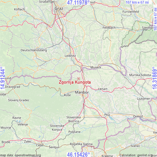
Zgornja Kungota GPS coordinates[2]
46° 38' 21.012" North, 15° 36' 56.016" East
| Map corner | latitude | longitude |
|---|---|---|
| Upper-left | 47.11978°, | 14.91244° |
| Center: | 46.63917°, | 15.61556° |
| Lower-right: | 46.15426°, | 16.31869° |
| Map W x H: | 107.4×107.4 km | = 66.7×66.7mi |
| max Lat: | 46.83694° ⇑5.3% North |
| Zgornja Kungota: | 46.63917° |
| min Lat: | ⇓94.7% South 45.47667° |
| min Long | Zgornja Kungota | max Long |
| 13.52639° | 15.61556° | 16.4975° |
| W 73%⇐ | ⇒27% E |
Elevation
Elevation of Zgornja Kungota is 273 m = 896 ft, and this is 52.6 m = 173 ft below average elevation for this country.
| Max E: |
1551 m = 5089 ft | 59.5% |
| Avg. | 325.6 m = 1068 ft | |
| Zgornja Kungota | 273 m = 896 ft | |
Min E: |
2 m = 7 ft | 40.5% |
See also: Slovenia elevation on elevation.city.
Geographical zone
Zgornja Kungota is located in North temperate zone (between Tropic of Cancer and the Arctic Circle). Distance of this North polar circle is 2215.4 km =1376.6 mi to North.| Distance of | km | miles | from Zgornja Kungota |
|---|---|---|---|
| North Pole | 4821.3 | 2995.8 | to North |
| Arctic Circle | 2215.4 | 1376.6 | to North |
| Tropic Cancer | 2579.9 | 1603.1 | to South |
| Equator | 5185.8 | 3222.3 | to South |


Nearby cities:
15 places around Zgornja Kungota: (largest is in red/bold)
• Bistrica ob Dravi
10.7 km =6.6 mi,  208°
208°
• Bresternica
8.3 km =5.2 mi,  201°
201°
• Ceršak
7.8 km =4.8 mi,  31°
31°
• Gačnik
6.9 km =4.3 mi,  111°
111°
• Gradiška
3.5 km =2.2 mi,  134°
134°
• Kamnica
7.2 km =4.5 mi,  180°
180°
• Kozjak nad Pesnico
3.5 km =2.2 mi,  156°
156°
• Limbuš
9.8 km =6.1 mi,  194°
194°
• Maribor
9.7 km =6 mi,  165°
165°
• Pekre
10.3 km =6.4 mi, 188°
• Pesnica pri Mariboru
5.9 km =3.7 mi, 127°
• Plintovec
0.3 km =0.2 mi,  124°
124°
• Selnica ob Muri
8.1 km =5 mi,  52°
52°
• Spodnji Slemen
10.2 km =6.3 mi,  218°
218°
• Šentilj v Slov. Goricah
5.3 km =3.3 mi, 27°
Sources, notices
• [Note1] Compared only with cities in Slovenia existing in our database
• [Src1] Map data: © OpenStreetMap contributors (CC-BY-SA)
• [Src2] Other city data from geonames.org with taken over terms of usage.
• [Src3] Geographical zone / Annual Mean Temperature by Robert A. Rohde @ Wikipedia
