Svätý Jur geodata
Svätý Jur (Bratislavský kraj) is a populated place; located in Slovakia in Europe/Bratislava (GMT+2) time zone. With population of 4,614 people, there are 114 cities with bigger population in this country. Compared to other cities in Slovakia, 82.9% of cities are located further ↑North; 95.3% of cities are located further →East and 79.4% of cities have higher elevation than Svätý Jur. Note1


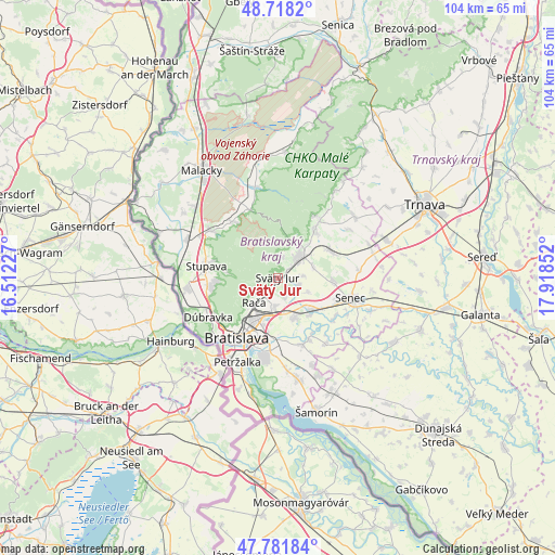
Svätý Jur GPS coordinates[2]
48° 15' 7.776" North, 17° 12' 55.404" East
| Map corner | latitude | longitude |
|---|---|---|
| Upper-left | 48.7182°, | 16.51227° |
| Center: | 48.25216°, | 17.21539° |
| Lower-right: | 47.78184°, | 17.91852° |
| Map W x H: | 104.1×104.1 km | = 64.7×64.7mi |
| max Lat: | 49.43503° ⇑82.9% North |
| Svätý Jur: | 48.25216° |
| min Lat: | ⇓17.1% South 47.76356° |
| min Long | Svätý Jur | max Long |
| 16.9786° | 17.21539° | 22.18136° |
| W 4.7%⇐ | ⇒95.3% E |
Elevation
Elevation of Svätý Jur is 152 m = 499 ft, and this is 184.1 m = 604 ft below average elevation for this country.
| Max E: |
1006 m = 3301 ft | 79.4% |
| Avg. | 336.1 m = 1103 ft | |
| Svätý Jur | 152 m = 499 ft | |
Min E: |
102 m = 335 ft | 20.6% |
See also: Slovakia elevation on elevation.city.
Geographical zone
Svätý Jur is located in North temperate zone (between Tropic of Cancer and the Arctic Circle). Distance of this North polar circle is 2036 km =1265.1 mi to North.| Distance of | km | miles | from Svätý Jur |
|---|---|---|---|
| North Pole | 4641.9 | 2884.3 | to North |
| Arctic Circle | 2036 | 1265.1 | to North |
| Tropic Cancer | 2759.2 | 1714.5 | to South |
| Equator | 5365.1 | 3333.7 | to South |


Nearby cities:
15 places around Svätý Jur: (largest is in red/bold)
• Bratislava
14.1 km =8.8 mi,  214°
214°
• Bratislava - Vajnory
5.2 km =3.2 mi,  186°
186°
• Devínska Nová Ves
18.2 km =11.3 mi,  254°
254°
• Dunajská Lužná
19.1 km =11.9 mi,  169°
169°
• Ivanka pri Dunaji
7.9 km =4.9 mi,  157°
157°
• Malacky
25 km =15.5 mi,  325°
325°
• Marianka
11.2 km =7 mi,  268°
268°
• Modra
11.3 km =7 mi,  36°
36°
• Pezinok
5.7 km =3.5 mi, 42°
• Senec
14.2 km =8.8 mi,  104°
104°
• Sládkovičovo
31.8 km =19.8 mi, 100°
• Stupava
13.8 km =8.6 mi,  280°
280°
• Trnava
30.8 km =19.1 mi,  63°
63°
• Vinosady
8.6 km =5.3 mi, 40°
• Šamorín
25.7 km =16 mi, 164°
Sources, notices
• [Note1] Compared only with cities in Slovakia existing in our database
• [Src1] Map data: © OpenStreetMap contributors (CC-BY-SA)
• [Src2] Other city data from geonames.org with taken over terms of usage.
• [Src3] Geographical zone / Annual Mean Temperature by Robert A. Rohde @ Wikipedia
