Senec geodata
Senec (Bratislavský kraj) is a seat of a second-order administrative division; located in Slovakia in Europe/Bratislava (GMT+2) time zone. With population of 14,673 people, there are 52 cities with bigger population in this country. Compared to other cities in Slovakia, 84.7% of cities are located further ↑North; 90% of cities are located further →East and 88.8% of cities have higher elevation than Senec. Note1


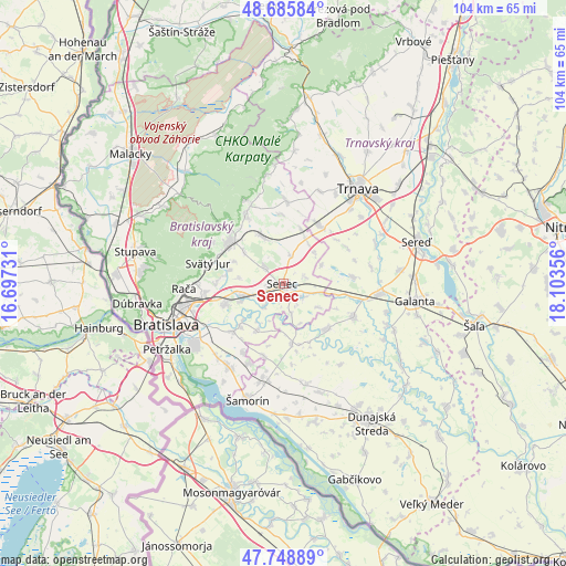
Senec GPS coordinates[2]
48° 13' 10.236" North, 17° 24' 1.548" East
| Map corner | latitude | longitude |
|---|---|---|
| Upper-left | 48.68584°, | 16.69731° |
| Center: | 48.21951°, | 17.40043° |
| Lower-right: | 47.74889°, | 18.10356° |
| Map W x H: | 104.2×104.2 km | = 64.7×64.7mi |
| max Lat: | 49.43503° ⇑84.7% North |
| Senec: | 48.21951° |
| min Lat: | ⇓15.3% South 47.76356° |
| min Long | Senec | max Long |
| 16.9786° | 17.40043° | 22.18136° |
| W 10%⇐ | ⇒90% E |
Elevation
Elevation of Senec is 127 m = 417 ft, and this is 209.1 m = 686 ft below average elevation for this country.
| Max E: |
1006 m = 3301 ft | 88.8% |
| Avg. | 336.1 m = 1103 ft | |
| Senec | 127 m = 417 ft | |
Min E: |
102 m = 335 ft | 11.2% |
See also: Slovakia elevation on elevation.city.
Geographical zone
Senec is located in North temperate zone (between Tropic of Cancer and the Arctic Circle). Distance of this North polar circle is 2039.7 km =1267.4 mi to North.| Distance of | km | miles | from Senec |
|---|---|---|---|
| North Pole | 4645.6 | 2886.6 | to North |
| Arctic Circle | 2039.7 | 1267.4 | to North |
| Tropic Cancer | 2755.6 | 1712.2 | to South |
| Equator | 5361.5 | 3331.5 | to South |


Nearby cities:
15 places around Senec: (largest is in red/bold)
• Bratislava
23.2 km =14.4 mi,  249°
249°
• Bratislava - Vajnory
14.4 km =8.9 mi,  263°
263°
• Dunajská Lužná
18.3 km =11.4 mi,  214°
214°
• Dunajská Streda
29.7 km =18.5 mi,  148°
148°
• Galanta
24.5 km =15.2 mi,  97°
97°
• Ivanka pri Dunaji
11.3 km =7 mi, 251°
• Marianka
25.1 km =15.6 mi,  277°
277°
• Modra
14.5 km =9 mi,  331°
331°
• Pezinok
12.6 km =7.8 mi,  308°
308°
• Sládkovičovo
17.8 km =11.1 mi, 96°
• Stupava
28 km =17.4 mi, 282°
• Svätý Jur
14.2 km =8.8 mi, 284°
• Trnava
22.3 km =13.9 mi,  38°
38°
• Vinosady
13.1 km =8.1 mi,  321°
321°
• Šamorín
22.1 km =13.7 mi,  197°
197°
Sources, notices
• [Note1] Compared only with cities in Slovakia existing in our database
• [Src1] Map data: © OpenStreetMap contributors (CC-BY-SA)
• [Src2] Other city data from geonames.org with taken over terms of usage.
• [Src3] Geographical zone / Annual Mean Temperature by Robert A. Rohde @ Wikipedia
