Šamorín geodata
Šamorín (Trnavský kraj) is a populated place; located in Slovakia in Europe/Bratislava (GMT+2) time zone. With population of 12,143 people, there are 60 cities with bigger population in this country. Compared to other cities in Slovakia, 94.1% of cities are located further ↑North; 91.2% of cities are located further →East and 90% of cities have higher elevation than Šamorín. Note1


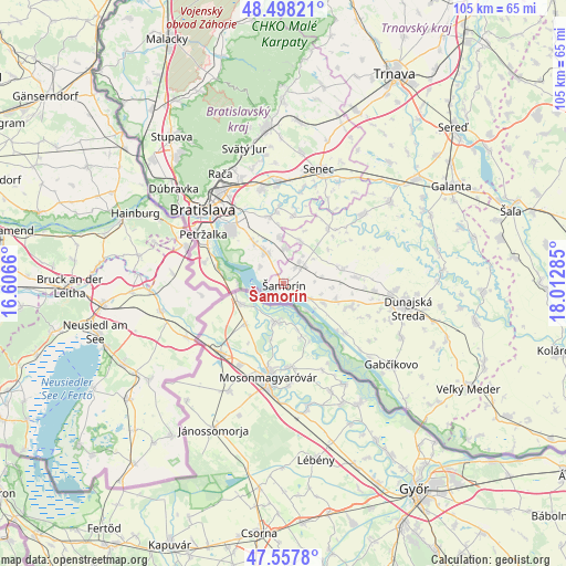
Šamorín GPS coordinates[2]
48° 1' 48.54" North, 17° 18' 34.992" East
| Map corner | latitude | longitude |
|---|---|---|
| Upper-left | 48.49821°, | 16.6066° |
| Center: | 48.03015°, | 17.30972° |
| Lower-right: | 47.5578°, | 18.01285° |
| Map W x H: | 104.6×104.6 km | = 65×65mi |
| max Lat: | 49.43503° ⇑94.1% North |
| Šamorín: | 48.03015° |
| min Lat: | ⇓5.9% South 47.76356° |
| min Long | Šamorín | max Long |
| 16.9786° | 17.30972° | 22.18136° |
| W 8.8%⇐ | ⇒91.2% E |
Elevation
Elevation of Šamorín is 125 m = 410 ft, and this is 211.1 m = 693 ft below average elevation for this country.
| Max E: |
1006 m = 3301 ft | 90% |
| Avg. | 336.1 m = 1103 ft | |
| Šamorín | 125 m = 410 ft | |
Min E: |
102 m = 335 ft | 10% |
See also: Slovakia elevation on elevation.city.
Geographical zone
Šamorín is located in North temperate zone (between Tropic of Cancer and the Arctic Circle). Distance of this North polar circle is 2060.7 km =1280.5 mi to North.| Distance of | km | miles | from Šamorín |
|---|---|---|---|
| North Pole | 4666.6 | 2899.7 | to North |
| Arctic Circle | 2060.7 | 1280.5 | to North |
| Tropic Cancer | 2734.5 | 1699.1 | to South |
| Equator | 5340.5 | 3318.4 | to South |


Nearby cities:
15 places around Šamorín: (largest is in red/bold)
• Bratislava
20 km =12.4 mi,  311°
311°
• Bratislava - Vajnory
20.9 km =13 mi,  338°
338°
• Devínska Nová Ves
31.5 km =19.6 mi, 308°
• Dunajská Lužná
7 km =4.3 mi,  328°
328°
• Dunajská Streda
22.9 km =14.2 mi,  100°
100°
• Gabčíkovo
25.2 km =15.7 mi,  127°
127°
• Ivanka pri Dunaji
17.9 km =11.1 mi,  346°
346°
• Marianka
30.4 km =18.9 mi,  323°
323°
• Modra
33.8 km =21 mi,  359°
359°
• Pezinok
29.1 km =18.1 mi, 353°
• Senec
22.1 km =13.7 mi,  17°
17°
• Sládkovičovo
31 km =19.3 mi,  52°
52°
• Stupava
34.1 km =21.2 mi, 322°
• Svätý Jur
25.7 km =16 mi, 344°
• Vinosady
31.3 km =19.4 mi, 357°
Sources, notices
• [Note1] Compared only with cities in Slovakia existing in our database
• [Src1] Map data: © OpenStreetMap contributors (CC-BY-SA)
• [Src2] Other city data from geonames.org with taken over terms of usage.
• [Src3] Geographical zone / Annual Mean Temperature by Robert A. Rohde @ Wikipedia
