Hybe geodata
Hybe (Žilinský kraj) is a populated place; located in Slovakia in Europe/Bratislava (GMT+2) time zone. With population of 1,548 people, there are 140 cities with bigger population in this country. Compared to other cities in Slovakia, 69.4% of cities are located further ↓South; 70% of cities are located further ←West and 94.7% of cities have lower elevation than Hybe. Note1


Hybe GPS coordinates[2]
49° 2' 39.804" North, 19° 49' 44.22" East
| Map corner | latitude | longitude |
|---|---|---|
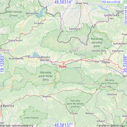
| Upper-left | 49.50314°, | 19.12583° |
| Center: | 49.04439°, | 19.82895° |
| Lower-right: | 48.58137°, | 20.53208° |
| Map W x H: | 102.5×102.5 km | = 63.7×63.7mi |
| max Lat: | 49.43503° ⇑30.6% North |
| Hybe: | 49.04439° |
| min Lat: | ⇓69.4% South 47.76356° |
| min Long | Hybe | max Long |
| 16.9786° | 19.82895° | 22.18136° |
| W 70%⇐ | ⇒30% E |
Elevation
Elevation of Hybe is 693 m = 2274 ft, and this is 356.9 m = 1171 ft above average elevation for this country.
| Max E: |
1006 m = 3301 ft | 5.3% |
| Hybe | 693 m 2274 ft | |
| Avg. | 336.1 m = 1103 ft | |
Min E: |
102 m = 335 ft | 94.7% |
See also: Slovakia elevation on elevation.city.
Geographical zone
Hybe is located in North temperate zone (between Tropic of Cancer and the Arctic Circle). Distance of this North polar circle is 1947.9 km =1210.4 mi to North.| Distance of | km | miles | from Hybe |
|---|---|---|---|
| North Pole | 4553.8 | 2829.6 | to North |
| Arctic Circle | 1947.9 | 1210.4 | to North |
| Tropic Cancer | 2847.3 | 1769.2 | to South |
| Equator | 5453.2 | 3388.5 | to South |


Nearby cities:
15 places around Hybe: (largest is in red/bold)
• Bešeňová
29.4 km =18.3 mi,  282°
282°
• Brezno
30.2 km =18.8 mi,  207°
207°
• Liptovská Sielnica
25.4 km =15.8 mi,  295°
295°
• Liptovský Hrádok
7.7 km =4.8 mi,  266°
266°
• Liptovský Mikuláš
15.6 km =9.7 mi, 284°
• Liptovský Trnovec
22.2 km =13.8 mi,  292°
292°
• Lúčky
32.5 km =20.2 mi, 286°
• Mýto pod Ďumbierom
25.8 km =16 mi, 213°
• Nová Lesná
33.1 km =20.6 mi,  74°
74°
• Pribylina
6.6 km =4.1 mi,  337°
337°
• Starý Smokovec
30.4 km =18.9 mi, 69°
• Svit
27.6 km =17.1 mi,  86°
86°
• Svätý Kríž
21.6 km =13.4 mi, 271°
• Vysoké Tatry
31.9 km =19.8 mi, 71°
• Štrba
18.3 km =11.4 mi,  84°
84°
Sources, notices
• [Note1] Compared only with cities in Slovakia existing in our database
• [Src1] Map data: © OpenStreetMap contributors (CC-BY-SA)
• [Src2] Other city data from geonames.org with taken over terms of usage.
• [Src3] Geographical zone / Annual Mean Temperature by Robert A. Rohde @ Wikipedia
