Revúca geodata
Revúca (Banskobystrický kraj) is a seat of a second-order administrative division; located in Slovakia in Europe/Bratislava (GMT+2) time zone. With population of 13,466 people, there are 54 cities with bigger population in this country. Compared to other cities in Slovakia, 59.4% of cities are located further ↑North; 72.4% of cities are located further ←West and 57.1% of cities have lower elevation than Revúca. Note1


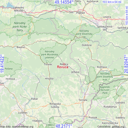
Revúca GPS coordinates[2]
48° 41' 0.456" North, 20° 7' 2.424" East
| Map corner | latitude | longitude |
|---|---|---|
| Upper-left | 49.14554°, | 19.41422° |
| Center: | 48.68346°, | 20.11734° |
| Lower-right: | 48.2171°, | 20.82047° |
| Map W x H: | 103.2×103.2 km | = 64.1×64.1mi |
| max Lat: | 49.43503° ⇑59.4% North |
| Revúca: | 48.68346° |
| min Lat: | ⇓40.6% South 47.76356° |
| min Long | Revúca | max Long |
| 16.9786° | 20.11734° | 22.18136° |
| W 72.4%⇐ | ⇒27.6% E |
Elevation
Elevation of Revúca is 318 m = 1043 ft, and this is 18.1 m = 59 ft below average elevation for this country.
| Max E: |
1006 m = 3301 ft | 42.9% |
| Avg. | 336.1 m = 1103 ft | |
| Revúca | 318 m = 1043 ft | |
Min E: |
102 m = 335 ft | 57.1% |
See also: Slovakia elevation on elevation.city.
Geographical zone
Revúca is located in North temperate zone (between Tropic of Cancer and the Arctic Circle). Distance of this North polar circle is 1988.1 km =1235.3 mi to North.| Distance of | km | miles | from Revúca |
|---|---|---|---|
| North Pole | 4594 | 2854.6 | to North |
| Arctic Circle | 1988.1 | 1235.3 | to North |
| Tropic Cancer | 2807.2 | 1744.3 | to South |
| Equator | 5413.1 | 3363.5 | to South |


Nearby cities:
15 places around Revúca: (largest is in red/bold)
• Betliar
28.8 km =17.9 mi,  85°
85°
• Brezno
37.7 km =23.4 mi,  290°
290°
• Dobšiná
24 km =14.9 mi,  50°
50°
• Hriňová
45 km =28 mi,  254°
254°
• Hybe
45.3 km =28.1 mi,  332°
332°
• Mýto pod Ďumbierom
40.2 km =25 mi,  297°
297°
• Poltár
36.8 km =22.9 mi,  220°
220°
• Poprad
44.1 km =27.4 mi,  17°
17°
• Rimavská Sobota
34.1 km =21.2 mi,  191°
191°
• Rožňava
31 km =19.3 mi, 94°
• Spišská Nová Ves
43.6 km =27.1 mi, 48°
• Svit
42.4 km =26.3 mi,  8°
8°
• Tisovec
12.8 km =8 mi,  266°
266°
• Čierny Balog
34.9 km =21.7 mi,  281°
281°
• Štrba
41.9 km =26 mi,  356°
356°
Sources, notices
• [Note1] Compared only with cities in Slovakia existing in our database
• [Src1] Map data: © OpenStreetMap contributors (CC-BY-SA)
• [Src2] Other city data from geonames.org with taken over terms of usage.
• [Src3] Geographical zone / Annual Mean Temperature by Robert A. Rohde @ Wikipedia
