Tombodu geodata
Tombodu (Eastern Province) is a populated place; located in Sierra Leone in Africa/Freetown (GMT+0) time zone. With population of 5,985 people, there are 34 cities with bigger population in this country. Compared to other cities in Sierra Leone, 63.9% of cities are located further ↑North; 96.4% of cities are located further ←West and 77.1% of cities have lower elevation than Tombodu. Note1


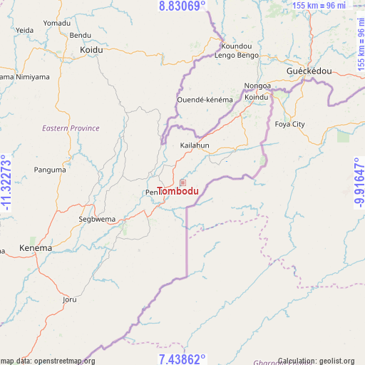
Tombodu GPS coordinates[2]
8° 8' 6.936" North, 10° 37' 10.56" West
| Map corner | latitude | longitude |
|---|---|---|
| Upper-left | 8.83069°, | -11.32273° |
| Center: | 8.13526°, | -10.6196° |
| Lower-right: | 7.43862°, | -9.91647° |
| Map W x H: | 154.8×154.8 km | = 96.2×96.2mi |
| max Lat: | 9.91376° ⇑63.9% North |
| Tombodu: | 8.13526° |
| min Lat: | ⇓36.1% South 7.24611° |
| min Long | Tombodu | max Long |
| -13.28972° | -10.6196° | -10.37135° |
| W 96.4%⇐ | ⇒3.6% E |
Elevation
Elevation of Tombodu is 275 m = 902 ft, and this is 117.8 m = 386 ft above average elevation for this country.
| Max E: |
564 m = 1850 ft | 22.9% |
| Tombodu | 275 m 902 ft | |
| Avg. | 157.2 m = 516 ft | |
Min E: |
1 m = 3 ft | 77.1% |
See also: Sierra Leone elevation on elevation.city.
Geographical zone
Tombodu is located in North Torrid zone (between Equator and Tropic of Cancer). Distance of Equator is 904.6 km =562.1 mi to South.| Distance of | km | miles | from Tombodu |
|---|---|---|---|
| North Pole | 9102.5 | 5656 | to North |
| Arctic Circle | 6496.6 | 4036.8 | to North |
| Tropic Cancer | 1701.4 | 1057.2 | to North |
| Equator | 904.6 | 562.1 | to South |


Nearby cities:
15 places around Tombodu: (largest is in red/bold)
• Buedu
31.7 km =19.7 mi,  59°
59°
• Bunumbu
27.3 km =17 mi,  279°
279°
• Daru
29.4 km =18.3 mi,  236°
236°
• Giehun
54.9 km =34.1 mi, 239°
• Giehun
65.9 km =40.9 mi,  315°
315°
• Hangha
61.4 km =38.2 mi,  249°
249°
• Jojoima
34.2 km =21.3 mi,  213°
213°
• Kailahun
16.8 km =10.4 mi,  17°
17°
• Manowa
14.8 km =9.2 mi,  286°
286°
• Mobai
21.6 km =13.4 mi,  223°
223°
• Panguma
56.8 km =35.3 mi, 275°
• Pendembu
9.2 km =5.7 mi, 243°
• Segbwema
39.6 km =24.6 mi, 246°
• Tombu
46.6 km =29 mi,  344°
344°
• Wima
66.9 km =41.6 mi, 285°
Sources, notices
• [Note1] Compared only with cities in Sierra Leone existing in our database
• [Src1] Map data: © OpenStreetMap contributors (CC-BY-SA)
• [Src2] Other city data from geonames.org with taken over terms of usage.
• [Src3] Geographical zone / Annual Mean Temperature by Robert A. Rohde @ Wikipedia
