Hangha geodata
Hangha (Eastern Province) is a populated place; located in Sierra Leone in Africa/Freetown (GMT+0) time zone. With population of 5,007 people, there are 45 cities with bigger population in this country. Compared to other cities in Sierra Leone, 75.9% of cities are located further ↑North; 77.1% of cities are located further ←West and 63.9% of cities have lower elevation than Hangha. Note1


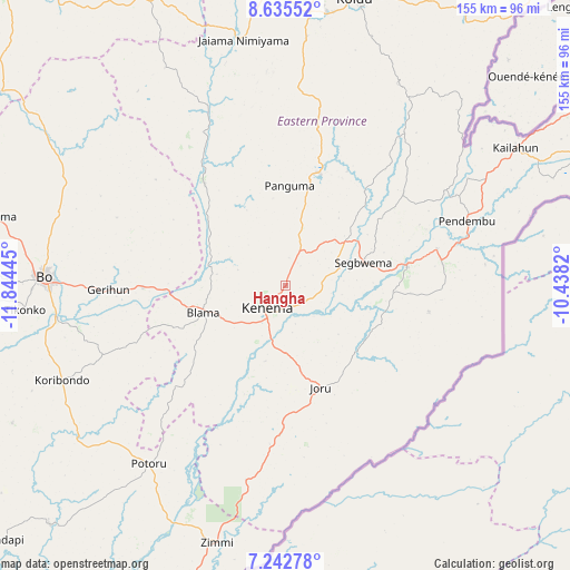
Hangha GPS coordinates[2]
7° 56' 23.064" North, 11° 8' 28.752" West
| Map corner | latitude | longitude |
|---|---|---|
| Upper-left | 8.63552°, | -11.84445° |
| Center: | 7.93974°, | -11.14132° |
| Lower-right: | 7.24278°, | -10.4382° |
| Map W x H: | 154.9×154.9 km | = 96.3×96.3mi |
| max Lat: | 9.91376° ⇑75.9% North |
| Hangha: | 7.93974° |
| min Lat: | ⇓24.1% South 7.24611° |
| min Long | Hangha | max Long |
| -13.28972° | -11.14132° | -10.37135° |
| W 77.1%⇐ | ⇒22.9% E |
Elevation
Elevation of Hangha is 176 m = 577 ft, and this is 18.8 m = 62 ft above average elevation for this country.
| Max E: |
564 m = 1850 ft | 36.1% |
| Hangha | 176 m 577 ft | |
| Avg. | 157.2 m = 516 ft | |
Min E: |
1 m = 3 ft | 63.9% |
See also: Sierra Leone elevation on elevation.city.
Geographical zone
Hangha is located in North Torrid zone (between Equator and Tropic of Cancer). Distance of Equator is 882.8 km =548.5 mi to South.| Distance of | km | miles | from Hangha |
|---|---|---|---|
| North Pole | 9124.2 | 5669.5 | to North |
| Arctic Circle | 6518.4 | 4050.3 | to North |
| Tropic Cancer | 1723.1 | 1070.7 | to North |
| Equator | 882.8 | 548.5 | to South |


Nearby cities:
15 places around Hangha: (largest is in red/bold)
• Barma
50.1 km =31.1 mi,  335°
335°
• Blama
23.6 km =14.7 mi,  252°
252°
• Boajibu
35.2 km =21.9 mi,  321°
321°
• Bunumbu
40.1 km =24.9 mi,  49°
49°
• Daru
33.4 km =20.8 mi,  80°
80°
• Giehun
11.9 km =7.4 mi,  121°
121°
• Jojoima
39.3 km =24.4 mi,  100°
100°
• Kenema
8.8 km =5.5 mi,  217°
217°
• Manowa
50.5 km =31.4 mi,  58°
58°
• Mobai
43.1 km =26.8 mi, 82°
• Palima
45 km =28 mi,  296°
296°
• Panguma
27.3 km =17 mi,  1°
1°
• Pendembu
52.3 km =32.5 mi,  70°
70°
• Segbwema
21.9 km =13.6 mi, 73°
• Wima
40.7 km =25.3 mi,  350°
350°
Sources, notices
• [Note1] Compared only with cities in Sierra Leone existing in our database
• [Src1] Map data: © OpenStreetMap contributors (CC-BY-SA)
• [Src2] Other city data from geonames.org with taken over terms of usage.
• [Src3] Geographical zone / Annual Mean Temperature by Robert A. Rohde @ Wikipedia
