Giehun geodata
Giehun (Eastern Province) is a populated place; located in Sierra Leone in Africa/Freetown (GMT+0) time zone. With population of 2,845 people, there are 78 cities with bigger population in this country. Compared to other cities in Sierra Leone, 59% of cities are located further ↓South; 80.7% of cities are located further ←West and 95.2% of cities have lower elevation than Giehun. Note1


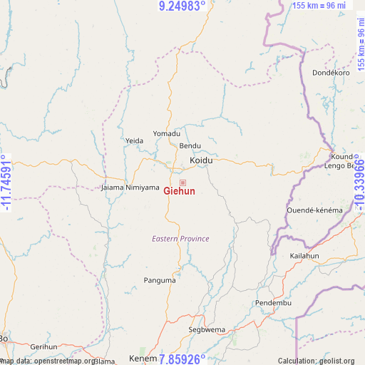
Giehun GPS coordinates[2]
8° 33' 18.648" North, 11° 2' 34.008" West
| Map corner | latitude | longitude |
|---|---|---|
| Upper-left | 9.24983°, | -11.74591° |
| Center: | 8.55518°, | -11.04278° |
| Lower-right: | 7.85926°, | -10.33966° |
| Map W x H: | 154.6×154.6 km | = 96.1×96.1mi |
| max Lat: | 9.91376° ⇑41% North |
| Giehun: | 8.55518° |
| min Lat: | ⇓59% South 7.24611° |
| min Long | Giehun | max Long |
| -13.28972° | -11.04278° | -10.37135° |
| W 80.7%⇐ | ⇒19.3% E |
Elevation
Elevation of Giehun is 405 m = 1329 ft, and this is 247.8 m = 813 ft above average elevation for this country.
| Max E: |
564 m = 1850 ft | 4.8% |
| Giehun | 405 m 1329 ft | |
| Avg. | 157.2 m = 516 ft | |
Min E: |
1 m = 3 ft | 95.2% |
See also: Sierra Leone elevation on elevation.city.
Geographical zone
Giehun is located in North Torrid zone (between Equator and Tropic of Cancer). Distance of Equator is 951.2 km =591 mi to South.| Distance of | km | miles | from Giehun |
|---|---|---|---|
| North Pole | 9055.8 | 5627 | to North |
| Arctic Circle | 6449.9 | 4007.8 | to North |
| Tropic Cancer | 1654.7 | 1028.2 | to North |
| Equator | 951.2 | 591 | to South |


Nearby cities:
15 places around Giehun: (largest is in red/bold)
• Barma
39 km =24.2 mi,  234°
234°
• Boajibu
52.4 km =32.6 mi,  218°
218°
• Bunumbu
46.7 km =29 mi,  155°
155°
• Kailahun
60.1 km =37.3 mi,  120°
120°
• Kayima
39.1 km =24.3 mi,  340°
340°
• Koidu
12.6 km =7.8 mi,  38°
38°
• Koyima
16.9 km =10.5 mi,  7°
7°
• Manowa
53.4 km =33.2 mi,  142°
142°
• Motema
7.4 km =4.6 mi,  26°
26°
• Panguma
42.3 km =26.3 mi,  193°
193°
• Simbakoro
7.5 km =4.7 mi, 31°
• Tefeya
24.9 km =15.5 mi,  311°
311°
• Tombu
34.3 km =21.3 mi,  92°
92°
• Wima
33.4 km =20.8 mi,  212°
212°
• Yengema
22.6 km =14 mi,  321°
321°
Sources, notices
• [Note1] Compared only with cities in Sierra Leone existing in our database
• [Src1] Map data: © OpenStreetMap contributors (CC-BY-SA)
• [Src2] Other city data from geonames.org with taken over terms of usage.
• [Src3] Geographical zone / Annual Mean Temperature by Robert A. Rohde @ Wikipedia
