Panguma geodata
Panguma (Eastern Province) is a populated place; located in Sierra Leone in Africa/Freetown (GMT+0) time zone. With population of 7,965 people, there are 24 cities with bigger population in this country. Compared to other cities in Sierra Leone, 59% of cities are located further ↑North; 78.3% of cities are located further ←West and 80.7% of cities have lower elevation than Panguma. Note1


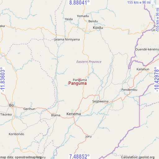
Panguma GPS coordinates[2]
8° 11' 6.252" North, 11° 7' 58.44" West
| Map corner | latitude | longitude |
|---|---|---|
| Upper-left | 8.88041°, | -11.83603° |
| Center: | 8.18507°, | -11.1329° |
| Lower-right: | 7.48852°, | -10.42978° |
| Map W x H: | 154.8×154.8 km | = 96.2×96.2mi |
| max Lat: | 9.91376° ⇑59% North |
| Panguma: | 8.18507° |
| min Lat: | ⇓41% South 7.24611° |
| min Long | Panguma | max Long |
| -13.28972° | -11.1329° | -10.37135° |
| W 78.3%⇐ | ⇒21.7% E |
Elevation
Elevation of Panguma is 309 m = 1014 ft, and this is 151.8 m = 498 ft above average elevation for this country.
| Max E: |
564 m = 1850 ft | 19.3% |
| Panguma | 309 m 1014 ft | |
| Avg. | 157.2 m = 516 ft | |
Min E: |
1 m = 3 ft | 80.7% |
See also: Sierra Leone elevation on elevation.city.
Geographical zone
Panguma is located in North Torrid zone (between Equator and Tropic of Cancer). Distance of Equator is 910.1 km =565.5 mi to South.| Distance of | km | miles | from Panguma |
|---|---|---|---|
| North Pole | 9097 | 5652.6 | to North |
| Arctic Circle | 6491.1 | 4033.4 | to North |
| Tropic Cancer | 1695.8 | 1053.7 | to North |
| Equator | 910.1 | 565.5 | to South |


Nearby cities:
15 places around Panguma: (largest is in red/bold)
• Barma
28.4 km =17.6 mi,  310°
310°
• Blama
41.7 km =25.9 mi,  214°
214°
• Boajibu
22.8 km =14.2 mi,  270°
270°
• Bunumbu
29.6 km =18.4 mi,  92°
92°
• Daru
38.7 km =24 mi,  124°
124°
• Giehun
34.7 km =21.6 mi,  164°
164°
• Giehun
42.3 km =26.3 mi,  13°
13°
• Hangha
27.3 km =17 mi,  181°
181°
• Kenema
34.8 km =21.6 mi,  190°
190°
• Manowa
42.3 km =26.3 mi, 91°
• Mobai
46.9 km =29.1 mi, 117°
• Palima
41.8 km =26 mi,  260°
260°
• Pendembu
49.2 km =30.6 mi,  101°
101°
• Segbwema
29.2 km =18.1 mi,  136°
136°
• Wima
15.1 km =9.4 mi,  328°
328°
Sources, notices
• [Note1] Compared only with cities in Sierra Leone existing in our database
• [Src1] Map data: © OpenStreetMap contributors (CC-BY-SA)
• [Src2] Other city data from geonames.org with taken over terms of usage.
• [Src3] Geographical zone / Annual Mean Temperature by Robert A. Rohde @ Wikipedia
