Foundiougne geodata
Foundiougne (Fatick) is a populated place; located in Senegal in Africa/Dakar (GMT+0) time zone. With population of 5,306 people, there are 50 cities with bigger population in this country. Compared to other cities in Senegal, 68.3% of cities are located further ↑North; 66.7% of cities are located further →East and 100% of cities have higher elevation than Foundiougne. Note1


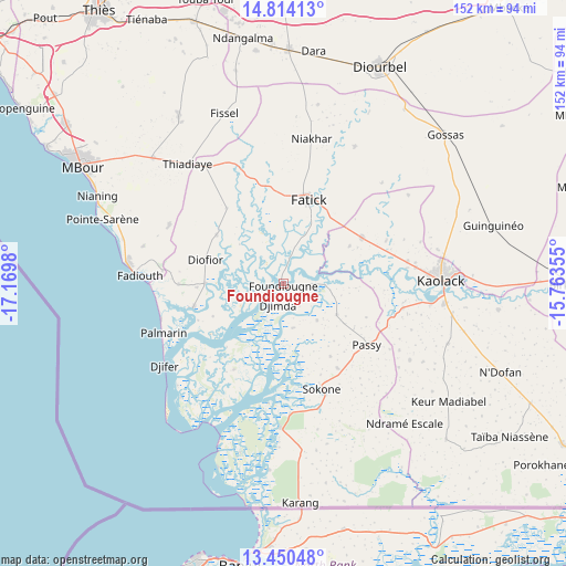
Foundiougne GPS coordinates[2]
14° 7' 59.988" North, 16° 28' 0.012" West
| Map corner | latitude | longitude |
|---|---|---|
| Upper-left | 14.81413°, | -17.1698° |
| Center: | 14.13333°, | -16.46667° |
| Lower-right: | 13.45048°, | -15.76355° |
| Map W x H: | 151.6×151.6 km | = 94.2×94.2mi |
| max Lat: | 16.51293° ⇑68.3% North |
| Foundiougne: | 14.13333° |
| min Lat: | ⇓31.7% South 12.485° |
| min Long | Foundiougne | max Long |
| -17.47581° | -16.46667° | -12.18076° |
| W 33.3%⇐ | ⇒66.7% E |
Elevation
Elevation of Foundiougne is 0 m = 0 ft, and this is 24.5 m = 80 ft below average elevation for this country.
| Max E: |
127 m = 417 ft | 100% |
| Avg. | 24.5 m = 80 ft | |
| Foundiougne | 0 m = 0 ft | |
Min E: |
0 m = 0 ft | 0% |
See also: Senegal elevation on elevation.city.
Geographical zone
Foundiougne is located in North Torrid zone (between Equator and Tropic of Cancer). Distance of this Northern Tropic circle is 1034.4 km =642.7 mi to North.| Distance of | km | miles | from Foundiougne |
|---|---|---|---|
| North Pole | 8435.6 | 5241.6 | to North |
| Arctic Circle | 5829.7 | 3622.4 | to North |
| Tropic Cancer | 1034.4 | 642.7 | to North |
| Equator | 1571.5 | 976.5 | to South |


Nearby cities:
15 places around Foundiougne: (largest is in red/bold)
• Baboucar Toumbou
27.4 km =17 mi,  264°
264°
• Diofior
22.3 km =13.9 mi,  284°
284°
• Diourbel
62.1 km =38.6 mi,  22°
22°
• Fatick
23.1 km =14.4 mi, 16°
• Gandiaye
24.3 km =15.1 mi,  62°
62°
• Guinguinéo
57.6 km =35.8 mi,  75°
75°
• Joal-Fadiout
39.7 km =24.7 mi, 275°
• Kaolack
42.5 km =26.4 mi,  87°
87°
• Keur Babakar Toumbou
27.3 km =17 mi, 264°
• Passi
27.3 km =17 mi,  127°
127°
• Pourham
24.7 km =15.3 mi,  12°
12°
• Sokone
29.8 km =18.5 mi,  158°
158°
• Tiadiaye
40.3 km =25 mi,  321°
321°
• Tiébo
61 km =37.9 mi, 24°
• Warang
57.9 km =36 mi,  297°
297°
Sources, notices
• [Note1] Compared only with cities in Senegal existing in our database
• [Src1] Map data: © OpenStreetMap contributors (CC-BY-SA)
• [Src2] Other city data from geonames.org with taken over terms of usage.
• [Src3] Geographical zone / Annual Mean Temperature by Robert A. Rohde @ Wikipedia
