Tiébo geodata
Tiébo (Diourbel) is a populated place; located in Senegal in Africa/Dakar (GMT+0) time zone. With population of 100,289 people, there are 8 cities with bigger population in this country. Compared to other cities in Senegal, 50% of cities are located further ↓South; 51.7% of cities are located further →East and 63.3% of cities have higher elevation than Tiébo. Note1


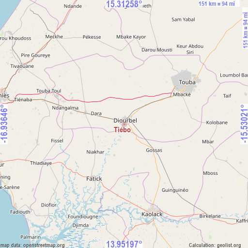
Tiébo GPS coordinates[2]
14° 37' 59.988" North, 16° 13' 59.988" West
| Map corner | latitude | longitude |
|---|---|---|
| Upper-left | 15.31258°, | -16.93646° |
| Center: | 14.63333°, | -16.23333° |
| Lower-right: | 13.95197°, | -15.53021° |
| Map W x H: | 151.3×151.3 km | = 94×94mi |
| max Lat: | 16.51293° ⇑50% North |
| Tiébo: | 14.63333° |
| min Lat: | ⇓50% South 12.485° |
| min Long | Tiébo | max Long |
| -17.47581° | -16.23333° | -12.18076° |
| W 48.3%⇐ | ⇒51.7% E |
Elevation
Elevation of Tiébo is 17 m = 56 ft, and this is 7.5 m = 25 ft below average elevation for this country.
| Max E: |
127 m = 417 ft | 63.3% |
| Avg. | 24.5 m = 80 ft | |
| Tiébo | 17 m = 56 ft | |
Min E: |
0 m = 0 ft | 36.7% |
See also: Tiébo elevation on elevation.city.
Geographical zone
Tiébo is located in North Torrid zone (between Equator and Tropic of Cancer). Distance of this Northern Tropic circle is 978.8 km =608.2 mi to North.| Distance of | km | miles | from Tiébo |
|---|---|---|---|
| North Pole | 8380 | 5207.1 | to North |
| Arctic Circle | 5774.1 | 3587.9 | to North |
| Tropic Cancer | 978.8 | 608.2 | to North |
| Equator | 1627.1 | 1011 | to South |


Nearby cities:
15 places around Tiébo: (largest is in red/bold)
• Diofior
68.4 km =42.5 mi,  223°
223°
• Diourbel
2 km =1.2 mi,  325°
325°
• Fatick
38.2 km =23.7 mi,  208°
208°
• Foundiougne
61 km =37.9 mi,  204°
204°
• Gandiaye
44.6 km =27.7 mi,  184°
184°
• Guinguinéo
50.9 km =31.6 mi,  143°
143°
• Kaolack
56.3 km =35 mi,  162°
162°
• Khombole
52.3 km =32.5 mi,  286°
286°
• Mbaké
39.1 km =24.3 mi,  63°
63°
• Mékhé
67.4 km =41.9 mi,  321°
321°
• Passi
72.4 km =45 mi, 182°
• Pourham
37.2 km =23.1 mi, 212°
• Thiès
76.5 km =47.5 mi,  283°
283°
• Tiadiaye
55.7 km =34.6 mi,  244°
244°
• Touba
44.7 km =27.8 mi, 57°
Sources, notices
• [Note1] Compared only with cities in Senegal existing in our database
• [Src1] Map data: © OpenStreetMap contributors (CC-BY-SA)
• [Src2] Other city data from geonames.org with taken over terms of usage.
• [Src3] Geographical zone / Annual Mean Temperature by Robert A. Rohde @ Wikipedia
