Pourham geodata
Pourham (Fatick) is a populated place; located in Senegal in Africa/Dakar (GMT+0) time zone. With population of 24,146 people, there are 20 cities with bigger population in this country. Compared to other cities in Senegal, 56.7% of cities are located further ↑North; 65% of cities are located further →East and 96.7% of cities have higher elevation than Pourham. Note1


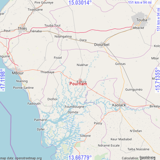
Pourham GPS coordinates[2]
14° 21' 0" North, 16° 25' 0.012" West
| Map corner | latitude | longitude |
|---|---|---|
| Upper-left | 15.03014°, | -17.1198° |
| Center: | 14.35°, | -16.41667° |
| Lower-right: | 13.66779°, | -15.71355° |
| Map W x H: | 151.5×151.5 km | = 94.1×94.1mi |
| max Lat: | 16.51293° ⇑56.7% North |
| Pourham: | 14.35° |
| min Lat: | ⇓43.3% South 12.485° |
| min Long | Pourham | max Long |
| -17.47581° | -16.41667° | -12.18076° |
| W 35%⇐ | ⇒65% E |
Elevation
Elevation of Pourham is 4 m = 13 ft, and this is 20.5 m = 67 ft below average elevation for this country.
| Max E: |
127 m = 417 ft | 96.7% |
| Avg. | 24.5 m = 80 ft | |
| Pourham | 4 m = 13 ft | |
Min E: |
0 m = 0 ft | 3.3% |
See also: Senegal elevation on elevation.city.
Geographical zone
Pourham is located in North Torrid zone (between Equator and Tropic of Cancer). Distance of this Northern Tropic circle is 1010.3 km =627.8 mi to North.| Distance of | km | miles | from Pourham |
|---|---|---|---|
| North Pole | 8411.5 | 5226.7 | to North |
| Arctic Circle | 5805.6 | 3607.4 | to North |
| Tropic Cancer | 1010.3 | 627.8 | to North |
| Equator | 1595.6 | 991.5 | to South |


Nearby cities:
15 places around Pourham: (largest is in red/bold)
• Baboucar Toumbou
42.2 km =26.2 mi,  230°
230°
• Diofior
32.7 km =20.3 mi,  235°
235°
• Diourbel
38 km =23.6 mi,  29°
29°
• Fatick
2.3 km =1.4 mi,  147°
147°
• Foundiougne
24.7 km =15.3 mi,  192°
192°
• Gandiaye
20.7 km =12.9 mi,  128°
128°
• Guinguinéo
51.1 km =31.8 mi,  100°
100°
• Joal-Fadiout
49.3 km =30.6 mi,  245°
245°
• Kaolack
43.1 km =26.8 mi,  120°
120°
• Keur Babakar Toumbou
42.2 km =26.2 mi, 230°
• Khombole
55.5 km =34.5 mi,  326°
326°
• Passi
43.9 km =27.3 mi,  158°
158°
• Sokone
52.2 km =32.4 mi,  174°
174°
• Tiadiaye
31.4 km =19.5 mi,  283°
283°
• Tiébo
37.2 km =23.1 mi, 32°
Sources, notices
• [Note1] Compared only with cities in Senegal existing in our database
• [Src1] Map data: © OpenStreetMap contributors (CC-BY-SA)
• [Src2] Other city data from geonames.org with taken over terms of usage.
• [Src3] Geographical zone / Annual Mean Temperature by Robert A. Rohde @ Wikipedia
