Guinguinéo geodata
Guinguinéo (Fatick) is a populated place; located in Senegal in Africa/Dakar (GMT+0) time zone. With population of 15,395 people, there are 29 cities with bigger population in this country. Compared to other cities in Senegal, 60% of cities are located further ↑North; 58.3% of cities are located further ←West and 58.3% of cities have lower elevation than Guinguinéo. Note1


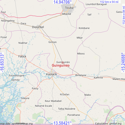
Guinguinéo GPS coordinates[2]
14° 16' 0.012" North, 15° 57' 0" West
| Map corner | latitude | longitude |
|---|---|---|
| Upper-left | 14.94706°, | -16.65313° |
| Center: | 14.26667°, | -15.95° |
| Lower-right: | 13.58421°, | -15.24688° |
| Map W x H: | 151.5×151.5 km | = 94.1×94.1mi |
| max Lat: | 16.51293° ⇑60% North |
| Guinguinéo: | 14.26667° |
| min Lat: | ⇓40% South 12.485° |
| min Long | Guinguinéo | max Long |
| -17.47581° | -15.95° | -12.18076° |
| W 58.3%⇐ | ⇒41.7% E |
Elevation
Elevation of Guinguinéo is 21 m = 69 ft, and this is 3.5 m = 11 ft below average elevation for this country.
| Max E: |
127 m = 417 ft | 41.7% |
| Avg. | 24.5 m = 80 ft | |
| Guinguinéo | 21 m = 69 ft | |
Min E: |
0 m = 0 ft | 58.3% |
See also: Senegal elevation on elevation.city.
Geographical zone
Guinguinéo is located in North Torrid zone (between Equator and Tropic of Cancer). Distance of this Northern Tropic circle is 1019.6 km =633.5 mi to North.| Distance of | km | miles | from Guinguinéo |
|---|---|---|---|
| North Pole | 8420.8 | 5232.4 | to North |
| Arctic Circle | 5814.9 | 3613.2 | to North |
| Tropic Cancer | 1019.6 | 633.5 | to North |
| Equator | 1586.3 | 985.7 | to South |


Nearby cities:
15 places around Guinguinéo: (largest is in red/bold)
• Diofior
77.8 km =48.3 mi,  263°
263°
• Diourbel
52.9 km =32.9 mi,  323°
323°
• Fatick
49.6 km =30.8 mi,  278°
278°
• Foundiougne
57.6 km =35.8 mi, 255°
• Gandiaye
34.3 km =21.3 mi, 263°
• Kaffrine
46.6 km =29 mi,  112°
112°
• Kaolack
18.4 km =11.4 mi,  226°
226°
• Mbaké
58.4 km =36.3 mi,  4°
4°
• Ndofane
39 km =24.2 mi,  177°
177°
• Nioro du Rip
59.7 km =37.1 mi,  164°
164°
• Passi
46.5 km =28.9 mi, 227°
• Pourham
51.1 km =31.8 mi, 280°
• Sokone
61.9 km =38.5 mi, 226°
• Tiébo
50.9 km =31.6 mi, 323°
• Touba
65.3 km =40.6 mi,  6°
6°
Sources, notices
• [Note1] Compared only with cities in Senegal existing in our database
• [Src1] Map data: © OpenStreetMap contributors (CC-BY-SA)
• [Src2] Other city data from geonames.org with taken over terms of usage.
• [Src3] Geographical zone / Annual Mean Temperature by Robert A. Rohde @ Wikipedia
