Kaolack geodata
Kaolack is a seat of a first-order administrative division; located in Senegal in Africa/Dakar (GMT+0) time zone. With population of 172,305 people, there are 6 cities with bigger population in this country. Compared to other cities in Senegal, 66.7% of cities are located further ↑North; 53.3% of cities are located further ←West and 93.3% of cities have higher elevation than Kaolack. Note1


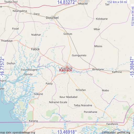
Kaolack GPS coordinates[2]
14° 9' 7.092" North, 16° 4' 21.324" West
| Map corner | latitude | longitude |
|---|---|---|
| Upper-left | 14.83272°, | -16.77572° |
| Center: | 14.15197°, | -16.07259° |
| Lower-right: | 13.46918°, | -15.36947° |
| Map W x H: | 151.6×151.6 km | = 94.2×94.2mi |
| max Lat: | 16.51293° ⇑66.7% North |
| Kaolack: | 14.15197° |
| min Lat: | ⇓33.3% South 12.485° |
| min Long | Kaolack | max Long |
| -17.47581° | -16.07259° | -12.18076° |
| W 53.3%⇐ | ⇒46.7% E |
Elevation
Elevation of Kaolack is 7 m = 23 ft, and this is 17.5 m = 57 ft below average elevation for this country.
| Max E: |
127 m = 417 ft | 93.3% |
| Avg. | 24.5 m = 80 ft | |
| Kaolack | 7 m = 23 ft | |
Min E: |
0 m = 0 ft | 6.7% |
See also: Kaolack elevation on elevation.city.
Geographical zone
Kaolack is located in North Torrid zone (between Equator and Tropic of Cancer). Distance of this Northern Tropic circle is 1032.4 km =641.5 mi to North.| Distance of | km | miles | from Kaolack |
|---|---|---|---|
| North Pole | 8433.5 | 5240.3 | to North |
| Arctic Circle | 5827.6 | 3621.1 | to North |
| Tropic Cancer | 1032.4 | 641.5 | to North |
| Equator | 1573.6 | 977.8 | to South |


Nearby cities:
15 places around Kaolack: (largest is in red/bold)
• Baboucar Toumbou
69.9 km =43.4 mi,  266°
266°
• Diofior
64.1 km =39.8 mi, 273°
• Diourbel
58.1 km =36.1 mi,  341°
341°
• Fatick
41.1 km =25.5 mi,  299°
299°
• Foundiougne
42.5 km =26.4 mi, 267°
• Gandiaye
22.8 km =14.2 mi,  293°
293°
• Guinguinéo
18.4 km =11.4 mi,  46°
46°
• Kaffrine
56.5 km =35.1 mi,  95°
95°
• Keur Babakar Toumbou
69.9 km =43.4 mi, 266°
• Ndofane
30.2 km =18.8 mi,  150°
150°
• Nioro du Rip
53.5 km =33.2 mi, 146°
• Passi
28.1 km =17.5 mi,  228°
228°
• Pourham
43.1 km =26.8 mi, 300°
• Sokone
43.6 km =27.1 mi, 226°
• Tiébo
56.3 km =35 mi, 342°
Sources, notices
• [Note1] Compared only with cities in Senegal existing in our database
• [Src1] Map data: © OpenStreetMap contributors (CC-BY-SA)
• [Src2] Other city data from geonames.org with taken over terms of usage.
• [Src3] Geographical zone / Annual Mean Temperature by Robert A. Rohde @ Wikipedia
