San Miguel geodata
San Miguel is a seat of a first-order administrative division; located in El Salvador in America/El_Salvador (GMT-6) time zone. With population of 161,880 people, there are 3 cities with bigger population in this country. Compared to other cities in El Salvador, 85% of cities are located further ↑North; 86% of cities are located further ←West and 88% of cities have higher elevation than San Miguel. Note1


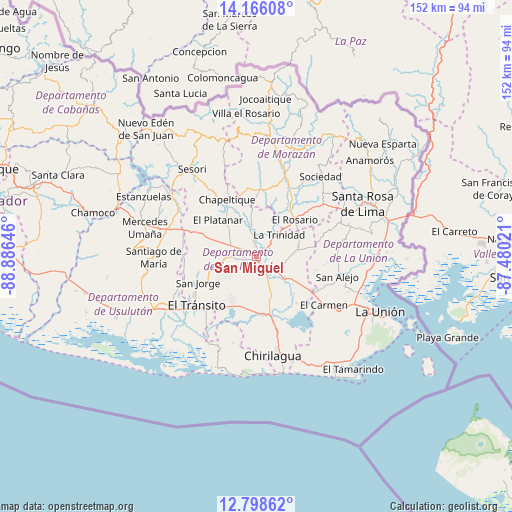
San Miguel GPS coordinates[2]
13° 28' 59.988" North, 88° 10' 59.988" West
| Map corner | latitude | longitude |
|---|---|---|
| Upper-left | 14.16608°, | -88.88646° |
| Center: | 13.48333°, | -88.18333° |
| Lower-right: | 12.79862°, | -87.48021° |
| Map W x H: | 152×152.1 km | = 94.4×94.5mi |
| max Lat: | 14.33333° ⇑85% North |
| San Miguel: | 13.48333° |
| min Lat: | ⇓15% South 13.19694° |
| min Long | San Miguel | max Long |
| -90.01583° | -88.18333° | -87.83861° |
| W 86%⇐ | ⇒14% E |
Elevation
Elevation of San Miguel is 130 m = 427 ft, and this is 341.9 m = 1122 ft below average elevation for this country.
| Max E: |
1255 m = 4117 ft | 88% |
| Avg. | 471.9 m = 1548 ft | |
| San Miguel | 130 m = 427 ft | |
Min E: |
13 m = 43 ft | 12% |
See also: San Miguel elevation on elevation.city.
Geographical zone
San Miguel is located in North Torrid zone (between Equator and Tropic of Cancer). Distance of this Northern Tropic circle is 1106.7 km =687.7 mi to North.| Distance of | km | miles | from San Miguel |
|---|---|---|---|
| North Pole | 8507.9 | 5286.6 | to North |
| Arctic Circle | 5902 | 3667.3 | to North |
| Tropic Cancer | 1106.7 | 687.7 | to North |
| Equator | 1499.2 | 931.6 | to South |


Nearby cities:
15 places around San Miguel: (largest is in red/bold)
• Chapeltique
19 km =11.8 mi,  331°
331°
• Chinameca
18.1 km =11.2 mi,  275°
275°
• Concepción Batres
24.8 km =15.4 mi,  233°
233°
• El Tránsito
23.3 km =14.5 mi, 230°
• Guatajiagua
20.5 km =12.7 mi,  354°
354°
• Jocoro
23.3 km =14.5 mi,  50°
50°
• Jucuapa
21.9 km =13.6 mi, 279°
• Jucuarán
26.4 km =16.4 mi,  195°
195°
• Lolotique
19.5 km =12.1 mi,  292°
292°
• Moncagua
9.1 km =5.7 mi,  307°
307°
• Nueva Guadalupe
18.9 km =11.7 mi, 287°
• San Alejo
24.5 km =15.2 mi,  103°
103°
• San Francisco
25.7 km =16 mi,  20°
20°
• San Rafael Oriente
21.2 km =13.2 mi,  238°
238°
• Santa Elena
27.6 km =17.1 mi,  246°
246°
Sources, notices
• [Note1] Compared only with cities in El Salvador existing in our database
• [Src1] Map data: © OpenStreetMap contributors (CC-BY-SA)
• [Src2] Other city data from geonames.org with taken over terms of usage.
• [Src3] Geographical zone / Annual Mean Temperature by Robert A. Rohde @ Wikipedia
