San Alejo geodata
San Alejo (La Unión) is a populated place; located in El Salvador in America/El_Salvador (GMT-6) time zone. With population of 5,149 people, there are 71 cities with bigger population in this country. Compared to other cities in El Salvador, 87% of cities are located further ↑North; 94% of cities are located further ←West and 84% of cities have higher elevation than San Alejo. Note1


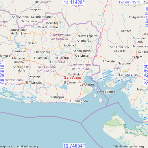
San Alejo GPS coordinates[2]
13° 25' 53.004" North, 87° 57' 47.016" West
| Map corner | latitude | longitude |
|---|---|---|
| Upper-left | 14.11429°, | -88.66619° |
| Center: | 13.43139°, | -87.96306° |
| Lower-right: | 12.74654°, | -87.25994° |
| Map W x H: | 152.1×152.1 km | = 94.5×94.5mi |
| max Lat: | 14.33333° ⇑87% North |
| San Alejo: | 13.43139° |
| min Lat: | ⇓13% South 13.19694° |
| min Long | San Alejo | max Long |
| -90.01583° | -87.96306° | -87.83861° |
| W 94%⇐ | ⇒6% E |
Elevation
Elevation of San Alejo is 177 m = 581 ft, and this is 294.9 m = 968 ft below average elevation for this country.
| Max E: |
1255 m = 4117 ft | 84% |
| Avg. | 471.9 m = 1548 ft | |
| San Alejo | 177 m = 581 ft | |
Min E: |
13 m = 43 ft | 16% |
See also: El Salvador elevation on elevation.city.
Geographical zone
San Alejo is located in North Torrid zone (between Equator and Tropic of Cancer). Distance of this Northern Tropic circle is 1112.5 km =691.3 mi to North.| Distance of | km | miles | from San Alejo |
|---|---|---|---|
| North Pole | 8513.6 | 5290.1 | to North |
| Arctic Circle | 5907.7 | 3670.9 | to North |
| Tropic Cancer | 1112.5 | 691.3 | to North |
| Equator | 1493.4 | 928 | to South |


Nearby cities:
15 places around San Alejo: (largest is in red/bold)
• Anamorós
35.7 km =22.2 mi,  15°
15°
• Cacaopera
39.5 km =24.5 mi,  340°
340°
• Chirilagua
30.2 km =18.8 mi,  218°
218°
• Conchagua
17.4 km =10.8 mi,  142°
142°
• Guatajiagua
36.6 km =22.7 mi,  315°
315°
• Intipucá
27.9 km =17.3 mi,  200°
200°
• Jocoro
21.4 km =13.3 mi, 344°
• Jucuarán
36.6 km =22.7 mi,  237°
237°
• La Unión
16.6 km =10.3 mi,  129°
129°
• Moncagua
33 km =20.5 mi,  290°
290°
• Pasaquina
21.5 km =13.4 mi,  37°
37°
• San Francisco
33.3 km =20.7 mi,  333°
333°
• San Miguel
24.5 km =15.2 mi,  283°
283°
• Santa Rosa de Lima
22.8 km =14.2 mi, 19°
• Sociedad
30.4 km =18.9 mi,  349°
349°
Sources, notices
• [Note1] Compared only with cities in El Salvador existing in our database
• [Src1] Map data: © OpenStreetMap contributors (CC-BY-SA)
• [Src2] Other city data from geonames.org with taken over terms of usage.
• [Src3] Geographical zone / Annual Mean Temperature by Robert A. Rohde @ Wikipedia
